IMAGES TAKEN NEAR TO
Two Burrows, Blackwater, TRURO, TR4 8HJ
Introduction
This page details the photographs taken nearby to TR4 8HJ by members of the Geograph project.
The Geograph project started in 2005 with the aim of publishing, organising and preserving representative images for every square kilometre of Great Britain, Ireland and the Isle of Man.

There are currently over 7.5m images from over14,400 individuals and you can help contribute to the project by visiting https://www.geograph.org.uk
Image Map
Images are licensed for reuse under creativecommons.org/licenses/by-sa/2.0
Notes
- Clicking on the map will re-center to the selected point.
- The higher the marker number, the further away the image location is from the centre of the postcode.
Image Listing (4 Images Found)
Images are licensed for reuse under creativecommons.org/licenses/by-sa/2.0
Image
Details
Distance
1
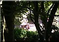
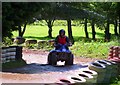
A Noise through the Trees
What's that noise? It turns out to be a dedicated track for quadbikes. It's better that the riders do it here than go tearing up some heathland.
Image: © Tony Atkin
Taken: 2 Jun 2006
0.09 miles
2
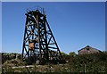
Winding Gear at Skinner's Bottom
This looks to be winding gear for a small mineshaft. It also looks to be derelict. My thanks go to Malcolm Kewn for providing the following explanation:
"This is the headgear of Wheal Concord, which was reopened in 1980, and visited by the Duke of Cornwall in 1981, who went underground during his visit. Tin output failed to reach expectations, however, and the tin market crash of 1985 proved to be the killer blow for this venture. The mine closed in 1986, hence the dereliction evident in the photo."
Image: © Tony Atkin
Taken: 2 Jun 2006
0.09 miles
4
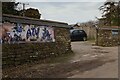
Entrance to the All-Terrain Vehicle Centre
Entrance to the All-Terrain Vehicle Centre at Blackwater.
Image: © Elizabeth Scott
Taken: 11 Nov 2023
0.18 miles