IMAGES TAKEN NEAR TO
Beach Road, TRURO, TR4 8FF
Introduction
This page details the photographs taken nearby to Beach Road, TR4 8FF by members of the Geograph project.
The Geograph project started in 2005 with the aim of publishing, organising and preserving representative images for every square kilometre of Great Britain, Ireland and the Isle of Man.

There are currently over 7.5m images from over14,400 individuals and you can help contribute to the project by visiting https://www.geograph.org.uk
Image Map
Images are licensed for reuse under creativecommons.org/licenses/by-sa/2.0
Notes
- Clicking on the map will re-center to the selected point.
- The higher the marker number, the further away the image location is from the centre of the postcode.
Image Listing (26 Images Found)
Images are licensed for reuse under creativecommons.org/licenses/by-sa/2.0
Image
Details
Distance
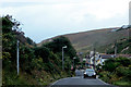
1
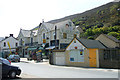
Houses on Beach Road, Porthtowan
Looking down Beach Road towards the sea.
Image: © Richard Law
Taken: 18 Sep 2012
0.02 miles
2
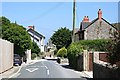
Porthtowan Main Street
This road is the older part of Porthtowan which was a village at the centre of a huge amount of mining activity.
Image: © Tony Atkin
Taken: 15 Jun 2006
0.03 miles
3
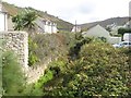
Porthtowan River
Running in a somewhat obscure course behind buildings old and new.
Image: © Jonathan Wilkins
Taken: 9 Sep 2019
0.04 miles
4
Village Store and Post Office, Porthtowan
Image: © Niki Walton
Taken: 5 May 2007
0.05 miles
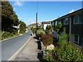
5
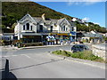
Beach Road, Porthtowan
A collection of small businesses on the main route through the village - a flower shop, backpackers' hostel, grocery/village store and chippy.
Image: © Richard Law
Taken: 18 Sep 2012
0.06 miles
6
Porthtowan
Looking upstream (southeast), this valley runs into the sea at Porth Towan
Image: © Steve Rigg
Taken: 4 Aug 2005
0.06 miles
7
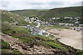
A View of Porthtowan
Taken from the clifftop overlooking the northern side of the bay.
Image: © Tony Atkin
Taken: 16 Jun 2007
0.07 miles
8
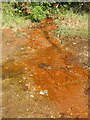
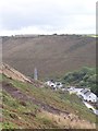
Ochre stream
The legacy of the mining of the district is complex. Now that there is no pumping, mines are flooded to the level of drainage adits, and water escapes through centuries of spoil and rubbish in the workings. Here water, laden with metals (though principally iron) is escaping into the adjacent Porthtowan River. The oxidation of the iron precipitates ochre (iron oxides and hydroxides) as it comes into contact with the air and forms puddles in this unsurfaced car parking area.
Image: © Jonathan Wilkins
Taken: 9 Sep 2019
0.07 miles
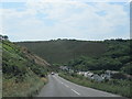
9
Near Porthtowan
The road approaching Porthtowan.
Image: © Robert Ashby
Taken: 17 Aug 2014
0.10 miles