IMAGES TAKEN NEAR TO
Blackwater, TRURO, TR4 8EU
Introduction
This page details the photographs taken nearby to TR4 8EU by members of the Geograph project.
The Geograph project started in 2005 with the aim of publishing, organising and preserving representative images for every square kilometre of Great Britain, Ireland and the Isle of Man.

There are currently over 7.5m images from over14,400 individuals and you can help contribute to the project by visiting https://www.geograph.org.uk
Image Map
Images are licensed for reuse under creativecommons.org/licenses/by-sa/2.0
Notes
- Clicking on the map will re-center to the selected point.
- The higher the marker number, the further away the image location is from the centre of the postcode.
Image Listing (13 Images Found)
Images are licensed for reuse under creativecommons.org/licenses/by-sa/2.0
Image
Details
Distance
1
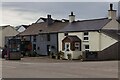
The Red Lion
The Red Lion, Blackwater. A free house.
Image: © Elizabeth Scott
Taken: 11 Nov 2023
0.02 miles
2
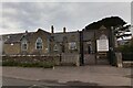
Blackwater Primary School 2
The modern extension is in keeping with the style of the main building, with modern Gothic-style windows. See also Image
Image: © Elizabeth Scott
Taken: 11 Nov 2023
0.07 miles
3
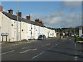
Houses on the old A30 road through Blackwater, St Agnes
Image: © Humphrey Bolton
Taken: 8 Jan 2016
0.08 miles
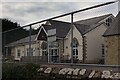
4
Blackwater Primary School 1
Built in 1877 as a Board School, it is now Grade II listed. See also Image
Image: © Elizabeth Scott
Taken: 11 Nov 2023
0.08 miles
5
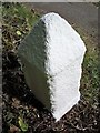
Old Milestone west of Blackwater, St Agnes parish
Carved stone post by the UC road (was A30), in parish of St Agnes (Carrick District), West of Blackwater, by the road, on North side of road. Erected by the parish in the 18th century.
No inscription:-
Two incised faces, one West, one North away from road.
The listing explains the original inscriptions.
Grade II listed.
List Entry Number: 1406160 https://historicengland.org.uk/listing/the-list/list-entry/1406160
Milestone Society National ID: CW_PZBM21
Image: © Ian Thompson
Taken: Unknown
0.10 miles
6
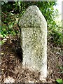
Old Milestone by the former A30
Carved stone post by the UC road (was A30), in parish of ST AGNES (CARRICK District), Southwest of Blackwater, by the road, on North side of road. Erected by the parish in the 18th century.
Inscription reads:-
: (No writing. Two incised faces, one West, one North away from road) :
Grade II listed.
List Entry Number: 1406160 https://historicengland.org.uk/listing/the-list/list-entry/1406160
Milestone Society National ID: CW_PZBM21.
Image: © Rosy Hanns
Taken: 6 Jul 2019
0.10 miles
7
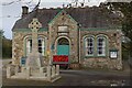
War Memorial and Passmore Edwards Institute
The war memorial stands in front of the Passmore Edwards Institute and Village Hall. There's a beautiful display of poppies behind the bench (I took the picture on Armistice Day). See also Image
Image: © Elizabeth Scott
Taken: 11 Nov 2023
0.13 miles
8
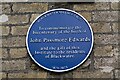
Plaque, Passmore Edwards Institute
A close look at the blue plaque commemorating Passmore Edwards on the wall of the Institute and Village Hall. See also Image
Image: © Elizabeth Scott
Taken: 11 Nov 2023
0.13 miles
9
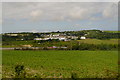
Towards Blackwater
The railway line and the A30 diverge here. Looking north across arable farmland from one to the other the village on the far side is Blackwater mainly in Image
This photo was taken from the 1158 Penzance to London Paddington train, having left Redruth at 1231.
Image: © Graham Horn
Taken: 9 Jul 2011
0.15 miles
10
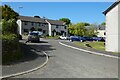
Passmore Close, Blackwater, St Agnes
A modern development near the centre of the bypassed village.
Image: © Andrew Smith
Taken: 13 May 2022
0.18 miles