IMAGES TAKEN NEAR TO
Porthtowan, TRURO, TR4 8AF
Introduction
This page details the photographs taken nearby to TR4 8AF by members of the Geograph project.
The Geograph project started in 2005 with the aim of publishing, organising and preserving representative images for every square kilometre of Great Britain, Ireland and the Isle of Man.

There are currently over 7.5m images from over14,400 individuals and you can help contribute to the project by visiting https://www.geograph.org.uk
Image Map
Images are licensed for reuse under creativecommons.org/licenses/by-sa/2.0
Notes
- Clicking on the map will re-center to the selected point.
- The higher the marker number, the further away the image location is from the centre of the postcode.
Image Listing (19 Images Found)
Images are licensed for reuse under creativecommons.org/licenses/by-sa/2.0
Image
Details
Distance
1
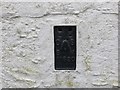
Ordnance Survey Flush Bracket 11620
This bracket can be found on the roadside wall of a commercial garage in Porthtowan. The benchmark height is recorded as being 20.218 metres above sea level.
For more detail see : http://www.bench-marks.org.uk/bm22539
Image: © Peter Wood
Taken: 3 May 2017
0.02 miles
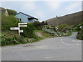
3

Old Direction Sign - Signpost in Porthtowan, St Agnes parish
Pyramid spear finial - 4 arms; by the UC road, in parish of St Agnes (Carrick District), South of Porthtowan, at road junction. For a more recent photo, see https://www.geograph.org.uk/photo/7860522.
Cornwall & Scilly HER.
HER Number: MCO55562 https://www.heritagegateway.org.uk/Gateway/Results_Single.aspx?uid=MCO55562&resourceID=1020
Surveyed
Milestone Society National ID: CW_SW6947B
Image: © Milestone Society
Taken: 1 Jan 2015
0.03 miles
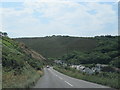
4
Road junction in Porthtowan
Looking south-eastward along the road to Mount Hawke.
Image: © Peter Wood
Taken: 3 May 2017
0.04 miles
5
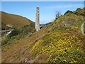
Engine house chimney
A delightful chimney emerging from charactersitic heathland. This appears to be associated with the South Wheal Towan mine, but it is situated at a low topgraphic leve, the better for draining the ground.
Image: © Jonathan Wilkins
Taken: 13 Sep 2019
0.04 miles
6
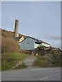
Bungalow and mine chimney, Rose Hill, Porthtowan
Image: © David Smith
Taken: 11 Mar 2016
0.07 miles
7
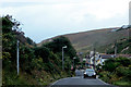
Near Porthtowan
The road approaching Porthtowan.
Image: © Robert Ashby
Taken: 17 Aug 2014
0.08 miles
8
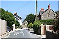
Houses on Beach Road, Porthtowan
Looking down Beach Road towards the sea.
Image: © Richard Law
Taken: 18 Sep 2012
0.12 miles
9
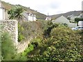
Porthtowan River
Running in a somewhat obscure course behind buildings old and new.
Image: © Jonathan Wilkins
Taken: 9 Sep 2019
0.15 miles
10
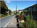
Porthtowan Main Street
This road is the older part of Porthtowan which was a village at the centre of a huge amount of mining activity.
Image: © Tony Atkin
Taken: 15 Jun 2006
0.16 miles