IMAGES TAKEN NEAR TO
Tarrandean Lane, TRURO, TR3 7NW
Introduction
This page details the photographs taken nearby to Tarrandean Lane, TR3 7NW by members of the Geograph project.
The Geograph project started in 2005 with the aim of publishing, organising and preserving representative images for every square kilometre of Great Britain, Ireland and the Isle of Man.

There are currently over 7.5m images from over14,400 individuals and you can help contribute to the project by visiting https://www.geograph.org.uk
Image Map
Images are licensed for reuse under creativecommons.org/licenses/by-sa/2.0
Notes
- Clicking on the map will re-center to the selected point.
- The higher the marker number, the further away the image location is from the centre of the postcode.
Image Listing (19 Images Found)
Images are licensed for reuse under creativecommons.org/licenses/by-sa/2.0
Image
Details
Distance
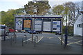
1
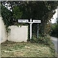
Direction Sign – Signpost at Perranwell Station
Located in Perranwell Station on a raised concrete plinth next to a domestic garage on the northwest side of the road to Carnon Roads. Perranarworthal parish. 2 arms and onion finial. See also https://www.geograph.org.uk/photo/6038323.
Milestone Society National ID: CW_SW7839
Image: © P Barnett
Taken: 23 Sep 2023
0.06 miles
2
Old Direction Sign - Signpost in Perranwell Station
2 arms and onion finial; by the UC road, in parish of Perranarworthal (Carrick District), Perranwell, side of road towards Devoran, on raised concrete next to domestic garage. See also https://www.geograph.org.uk/photo/7612368.
To be surveyed
Milestone Society National ID: CW_SW7839.
Image: © Milestone Society
Taken: 1 Jan 2013
0.06 miles
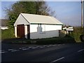
4
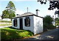
Perranwell Tollhouse by Terrandean Lane, Perranarworthal
Tollhouse in the parish of Perranarworthal (Carrick District), Toll House, Tarrandean Lane.
Grade II listed.
List Entry Number: 1141600 https://historicengland.org.uk/listing/the-list/list-entry/1141600
Surveyed
Milestone Society National ID: CW.PER
Image: © Alan Rosevear
Taken: 10 Sep 2014
0.09 miles
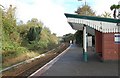
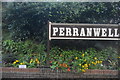
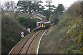
5
Outside Perranwell Railway Station
The village sized settlement which has grown up adjacent to the railway station is itself called "Perranwell Station".
Image: © Tony Atkin
Taken: 6 Apr 2006
0.11 miles
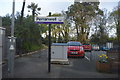
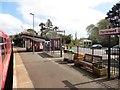
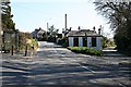
9
Perranwell Station
A class 153 unit passes through Perranwell station; trains call here only by request, but even then only every other train does so and this was not one of them. The station was opened in 1864, the year after the Truro - Falmouth branch itself. The speed signs indicate a differential speed restriction whereby trains are ordinarily restricted to 30mph but multiple units (which in fact form the vast majority of the traffic here) may pass at 35 mph.
Image: © Stephen McKay
Taken: 31 Mar 2010
0.13 miles