IMAGES TAKEN NEAR TO
Tregonning Road, TRURO, TR3 7FG
Introduction
This page details the photographs taken nearby to Tregonning Road, TR3 7FG by members of the Geograph project.
The Geograph project started in 2005 with the aim of publishing, organising and preserving representative images for every square kilometre of Great Britain, Ireland and the Isle of Man.

There are currently over 7.5m images from over14,400 individuals and you can help contribute to the project by visiting https://www.geograph.org.uk
Image Map
Images are licensed for reuse under creativecommons.org/licenses/by-sa/2.0
Notes
- Clicking on the map will re-center to the selected point.
- The higher the marker number, the further away the image location is from the centre of the postcode.
Image Listing (7 Images Found)
Images are licensed for reuse under creativecommons.org/licenses/by-sa/2.0
Image
Details
Distance
1
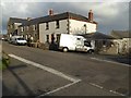
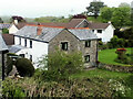
Houses in Stithians
Houses on East Road in Stithians.
Image: © Philip Halling
Taken: 7 Nov 2017
0.10 miles
3
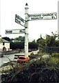
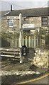
Old Direction Sign - Signpost by Gribbas Corner, Stithians
Pyramid spear finial - 4 arms; Cornwall CC iron spear by the UC road, in parish of Stithians (Kerrier District), opposite Tregonning Road turn, crossroads of South Road, New Road, East Road and Tregonning Road at Gribbas Corner.
Grade II listed.
List Entry Number: 1142030 https://historicengland.org.uk/listing/the-list/list-entry/1142030
Surveyed
Milestone Society National ID: CW_SW7336
Image: © Milestone Society
Taken: Unknown
0.11 miles
4
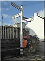
Roadsign in Stithians
This roadsign in Stithans dates from the 1920s and is Grade II listed. https://historicengland.org.uk/listing/the-list/list-entry/1142030
Image: © Philip Halling
Taken: 7 Nov 2017
0.11 miles
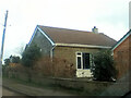
7
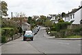
New Housing in Stithians
In addition to the mainly 19th century core of the village this modern housing has been added. The extra population probably helps to keep services such as a village shop and primary school which might not otherwise have been viable.
Image: © Tony Atkin
Taken: 7 May 2006
0.25 miles