IMAGES TAKEN NEAR TO
Restronguet Point, TRURO, TR3 6RB
Introduction
This page details the photographs taken nearby to Restronguet Point, TR3 6RB by members of the Geograph project.
The Geograph project started in 2005 with the aim of publishing, organising and preserving representative images for every square kilometre of Great Britain, Ireland and the Isle of Man.

There are currently over 7.5m images from over14,400 individuals and you can help contribute to the project by visiting https://www.geograph.org.uk
Image Map
Images are licensed for reuse under creativecommons.org/licenses/by-sa/2.0
Notes
- Clicking on the map will re-center to the selected point.
- The higher the marker number, the further away the image location is from the centre of the postcode.
Image Listing (9 Images Found)
Images are licensed for reuse under creativecommons.org/licenses/by-sa/2.0
Image
Details
Distance
1
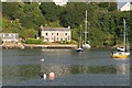
The riverfront near Restronguet Point
Taken from the River Fal
Image: © Ian S
Taken: 4 Apr 2015
0.06 miles
2
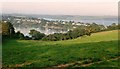
Restronguet Creek
From Restronguet Hill, looking across the creek to houses at Harcourt and along Restronguet Point, with Carrick Roads beyond.
Image: © Derek Harper
Taken: 17 Aug 1993
0.08 miles

4
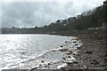
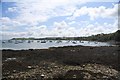
Carrick Roads, the foreshore below Porthgwidden
Low water at spring tides is the only time one is able to get here which, in this part of the UK, is just after midday when shooting into the sun is unavoidable.
Image: © Fred James
Taken: 20 Feb 2007
0.13 miles
5
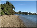
Restronguet Creek shore
Looking along the shore at high tide, with distant views of the lavish housing on the top of the peninsula.
Image: © Jonathan Wilkins
Taken: 10 Sep 2019
0.13 miles
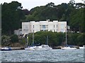
6
Former ferryman?s cottage Restronguet Creek
Image: © Fred James
Taken: 26 Jun 2009
0.14 miles
7
Carrick Roads: Panorama from Loe Beach
Panorama from Loe Beach taking in (moving anticlockwise) the moorings and sea-weed bestrewn foreshore at Loe Beach, round past Porthgwidden, Restronguet Point at the mouth of Restronguet Creek, Mylor Yacht Harbour at the mouth of the Mylor River, and Penarrow Point, with some ships just visible moored in Falmouth bay.
Image: © Graham Loveland
Taken: 30 Apr 2009
0.16 miles
8
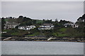
Part of "Millionaires' Mile"
The locals refer to a one mile stretch of the banks of the River Fal as Millionaires' Mile in reference to the minimum property price in that area.
Image: © Steve Barnes
Taken: 6 Aug 2011
0.21 miles
9
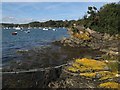
Mylor Slate Formation outcrop
The tip of Restronguet Point comprises outcrop of the Mylor Slates Formation, a group of siltstones and slates of Devonian age. They are obviously hard here, because Caloplaca lichens have found a good substrate and developed fine colour. If rock is too soft, the whole lot weathers faster than the lichen can grow. It made me happy to see this, as I was reminded of the hard rocks of Wales, and it was compensation for crawling through a web of mooring lines.
Image: © Jonathan Wilkins
Taken: 10 Sep 2019
0.24 miles