IMAGES TAKEN NEAR TO
Besore, TRURO, TR3 6BL
Introduction
This page details the photographs taken nearby to Besore, TR3 6BL by members of the Geograph project.
The Geograph project started in 2005 with the aim of publishing, organising and preserving representative images for every square kilometre of Great Britain, Ireland and the Isle of Man.

There are currently over 7.5m images from over14,400 individuals and you can help contribute to the project by visiting https://www.geograph.org.uk
Image Map
Images are licensed for reuse under creativecommons.org/licenses/by-sa/2.0
Notes
- Clicking on the map will re-center to the selected point.
- The higher the marker number, the further away the image location is from the centre of the postcode.
Image Listing (8 Images Found)
Images are licensed for reuse under creativecommons.org/licenses/by-sa/2.0
Image
Details
Distance
3
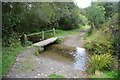
Hugus Ford
This ford is found at Hugus near Threemilestone.
Image: © John Walton
Taken: 23 Sep 2015
0.08 miles
7
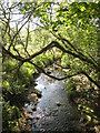
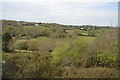
Stream near Hugos Farm
This stream eventually feeds into Calenick Creek
Image: © Rod Allday
Taken: 13 May 2008
0.17 miles
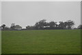
8
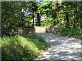
Bridge over stream near Hugos Farm
This is on the minor road between Mount Prickle and Hugus
Image: © Rod Allday
Taken: 13 May 2008
0.19 miles