IMAGES TAKEN NEAR TO
Lelant Downs, HAYLE, TR27 6NN
Introduction
This page details the photographs taken nearby to TR27 6NN by members of the Geograph project.
The Geograph project started in 2005 with the aim of publishing, organising and preserving representative images for every square kilometre of Great Britain, Ireland and the Isle of Man.

There are currently over 7.5m images from over14,400 individuals and you can help contribute to the project by visiting https://www.geograph.org.uk
Image Map
Images are licensed for reuse under creativecommons.org/licenses/by-sa/2.0
Notes
- Clicking on the map will re-center to the selected point.
- The higher the marker number, the further away the image location is from the centre of the postcode.
Image Listing (8 Images Found)
Images are licensed for reuse under creativecommons.org/licenses/by-sa/2.0
Image
Details
Distance
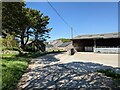

6
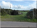
The start of the bridle path
This path is just about impassable on foot, and definitely impassable on a bike. A big contrast to the 'improved' section just 400 metres away. See: www.geograph.org.uk/photo/540454
Image: © David Medcalf
Taken: 7 Sep 2013
0.18 miles
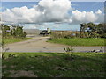
7
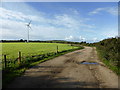
New farm lane at Trembethow
This lane is not shown on the OS Map, though it appears on Google Earth and the OS Aerial view on Get-a-Map.
Image: © David Medcalf
Taken: 7 Sep 2013
0.19 miles
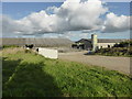
8
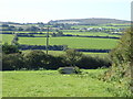
Fields near Trembethow
The building on the skyline is Image, with Castle-an-Dinas quarry to the left of it.
Image: © Rod Allday
Taken: 27 Sep 2018
0.20 miles