IMAGES TAKEN NEAR TO
Back Lane, HAYLE, TR27 6NF
Introduction
This page details the photographs taken nearby to Back Lane, TR27 6NF by members of the Geograph project.
The Geograph project started in 2005 with the aim of publishing, organising and preserving representative images for every square kilometre of Great Britain, Ireland and the Isle of Man.

There are currently over 7.5m images from over14,400 individuals and you can help contribute to the project by visiting https://www.geograph.org.uk
Image Map
Images are licensed for reuse under creativecommons.org/licenses/by-sa/2.0
Notes
- Clicking on the map will re-center to the selected point.
- The higher the marker number, the further away the image location is from the centre of the postcode.
Image Listing (23 Images Found)
Images are licensed for reuse under creativecommons.org/licenses/by-sa/2.0
Image
Details
Distance
1

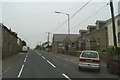
Former Wesleyan chapel
Sunday school on left
Image: © Paul Barnett
Taken: 19 Oct 2015
0.06 miles
5
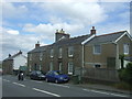
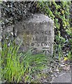
The lane to Gorran
Looking eastwards. There are far more houses here than are shown on the OS Map.
Image: © David Medcalf
Taken: 7 Sep 2013
0.12 miles
8
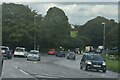
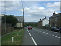
Canon's Town : A30
Looking along the A30.
Image: © Lewis Clarke
Taken: 28 Sep 2022
0.14 miles
10
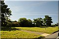
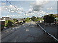
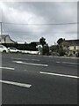
Penwith : The A30 Roadside
The green grass on the roadside beside the A30 road.
Image: © Lewis Clarke
Taken: 2 Jul 2011
0.15 miles