IMAGES TAKEN NEAR TO
Lelant Downs, HAYLE, TR27 6LH
Introduction
This page details the photographs taken nearby to TR27 6LH by members of the Geograph project.
The Geograph project started in 2005 with the aim of publishing, organising and preserving representative images for every square kilometre of Great Britain, Ireland and the Isle of Man.

There are currently over 7.5m images from over14,400 individuals and you can help contribute to the project by visiting https://www.geograph.org.uk
Image Map
Images are licensed for reuse under creativecommons.org/licenses/by-sa/2.0
Notes
- Clicking on the map will re-center to the selected point.
- The higher the marker number, the further away the image location is from the centre of the postcode.
Image Listing (17 Images Found)
Images are licensed for reuse under creativecommons.org/licenses/by-sa/2.0
Image
Details
Distance
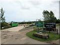
2
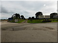
The entrance to Splattenridden industrial complex
Image: © David Medcalf
Taken: 7 Sep 2013
0.11 miles
3
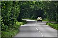
Penwith : Road
A road in Penwith which is also the day trip route to St Ives.
Image: © Lewis Clarke
Taken: 1 Jul 2011
0.11 miles
4
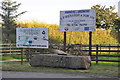
Penwith : CP Richards and Son sign
A sign for a farmers and growers and the Green Waste Company.
Image: © Lewis Clarke
Taken: 2 Jul 2011
0.11 miles
5
Entrance to Richards & Sons Ltd, Splatteridden
Image: © Roy Hughes
Taken: 27 Jun 2022
0.11 miles
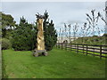
6
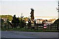
Penwith : Sculpture
A sculpture or statue at the entrance of an industrial or agricultural unit.
Image: © Lewis Clarke
Taken: 2 Jul 2011
0.11 miles
7
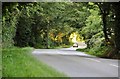
Penwith : Road
A road between Leland and Lelant Downs.
Image: © Lewis Clarke
Taken: 2 Jul 2011
0.12 miles
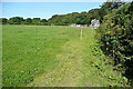
8
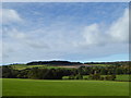
Field at Splattenridden
Looking towards Beersheba Plantation on top of the hill, in square Image
Image: © Rod Allday
Taken: 8 Oct 2015
0.15 miles
9
Near Splattenridden
This footpath follows field boundaries to reach this house by the road near the wonderfully named Splattenridden.
Image: © Graham Horn
Taken: 2 Jul 2011
0.19 miles
10
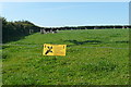
Pasture at Rose-an-Grouse
The public footpath is separated from the field, and the cows, by an electric fence, in some places a bit too close for comfort though.
Image: © Graham Horn
Taken: 2 Jul 2011
0.19 miles