IMAGES TAKEN NEAR TO
Rose-An-Grouse, HAYLE, TR27 6JN
Introduction
This page details the photographs taken nearby to Rose-An-Grouse, TR27 6JN by members of the Geograph project.
The Geograph project started in 2005 with the aim of publishing, organising and preserving representative images for every square kilometre of Great Britain, Ireland and the Isle of Man.

There are currently over 7.5m images from over14,400 individuals and you can help contribute to the project by visiting https://www.geograph.org.uk
Image Map
Images are licensed for reuse under creativecommons.org/licenses/by-sa/2.0
Notes
- Clicking on the map will re-center to the selected point.
- The higher the marker number, the further away the image location is from the centre of the postcode.
Image Listing (130 Images Found)
Images are licensed for reuse under creativecommons.org/licenses/by-sa/2.0
Image
Details
Distance

3
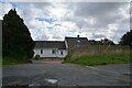
St Erth : House
A house alongside the A30.
Image: © Lewis Clarke
Taken: 28 Sep 2022
0.04 miles
4
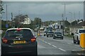
St Erth : A30
Heading along the A30 through St Erth.
Image: © Lewis Clarke
Taken: 28 Sep 2022
0.04 miles
5
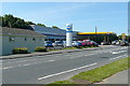
St Erth service station
Perhaps a welcome break for some, but most people will be nearing the ends of their journeys with Land's End just 20 miles further along the A30. Or you can buy a used Fiat for your journey home.
Image: © Graham Horn
Taken: 2 Jul 2011
0.05 miles
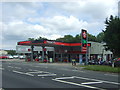
7

Texaco service station on the A30 near St Erth
Image: © Roger Cornfoot
Taken: 19 Apr 2018
0.06 miles
8
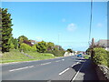
A30 west of St Erth Station
Approaching a slightly built up stretch of the road for a quarter of a mile west of the railway station.
Image: © Richard Vince
Taken: 3 Oct 2023
0.06 miles
9
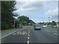
Bus stop and shelter on the A30, Rose-an-Grouse
Image: © JThomas
Taken: 13 Jul 2017
0.07 miles
10
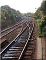
St Erth railway station photo-survey (28)
Looking in the down (west) direction from St Erth railway station's platform 2 at the trailing crossover between the up (nearest camera) and down lines with the up home signal silhouetted. The square sign bearing the numeral '10' indicates the stopping point for ten-coach trains.
Train movements through the station are controlled from St Erth signal box (see [http://www.geograph.org.uk/photo/1554897] ) in the traditional manner by semaphore signals and mechanically-operated (as opposed to electrically-operated) points.
The well-maintained St Erth railway station in Cornwall is on the former Great Western Railway (GWR) West of England main line. It is the junction for the St Ives branch line and retains a traditional appearance with its handsome granite buildings, wooden valanced canopies and semaphore signalling. The station is east of the A30 road near Lelant and is over a mile from the village from which it takes its name.
The original single-platform station (built by the West Cornwall Railway in 1852) was rebuilt by the GWR after the St Ives branch opened in the 1870s. The mainline was originally single-track but the line was doubled eastwards in 1899 and westwards in 1929. The St Ives branch was built as, and remained, a single-track line.
There are three platforms in use at St Erth station. Platform 1 is a facing platform serving the down (westbound) main line. Platform 2 serves the up (eastbound) main line. The two main line platforms can accommodate eight-car trains and are connected by a covered footbridge of GWR vintage (the bridge provides the only access to platform 1). Platform 3 is a terminal bay platform serving the St Ives branch. The west end of platform 2 is a facing platform but the east end forms an island platform (albeit on two levels) with platform 3. There is also a short loading dock on a second track in the St Ives branch bay.
Beyond the up (east) end of the station, the St Ives branch curves sharply north and St Erth signal box, which dates from 1899, is situated between the main line and the diverging branch. There is a fan of sidings opposite the signal box on the south side of the main line.
St Erth station is managed by First Great Western (FGW) which operates most of the services. The St Ives service is operated as an out-and-back shuttle by FGW (though a few branch trains are extended to and from Penzance). The company also operates local stopping services between Plymouth and Penzance and FGW expresses from London to Penzance stop at St Erth. CrossCountry operates daily services to and from the Midlands, the north and Scotland. South West Trains operates infrequent services to London Waterloo.
For pictures of St Erth station in 1979 and 1981 see [http://www.geograph.org.uk/photo/1005319] and [http://www.geograph.org.uk/photo/604669] .
Image: © Andy F
Taken: 17 Oct 2009
0.07 miles