IMAGES TAKEN NEAR TO
Carnsew Road, HAYLE, TR27 6JE
Introduction
This page details the photographs taken nearby to Carnsew Road, TR27 6JE by members of the Geograph project.
The Geograph project started in 2005 with the aim of publishing, organising and preserving representative images for every square kilometre of Great Britain, Ireland and the Isle of Man.

There are currently over 7.5m images from over14,400 individuals and you can help contribute to the project by visiting https://www.geograph.org.uk
Image Map
Images are licensed for reuse under creativecommons.org/licenses/by-sa/2.0
Notes
- Clicking on the map will re-center to the selected point.
- The higher the marker number, the further away the image location is from the centre of the postcode.
Image Listing (18 Images Found)
Images are licensed for reuse under creativecommons.org/licenses/by-sa/2.0
Image
Details
Distance
1
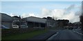
Factory entrance, Hayle
A modern factory between the Causeway and the Hayle estuary
Image: © David Smith
Taken: 17 Jan 2014
0.03 miles
3
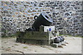
Crimean siege mortar
Cast 1856 and weighs 5 tons. 13" bore with a choked barrel. Built by local company Harveys.
Image: © Chris Allen
Taken: 22 Sep 2008
0.15 miles
4
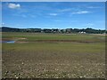
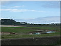
Hayle river and harbour from Riviere Towans
Image: © Peter Jemmett
Taken: 25 Aug 2008
0.16 miles
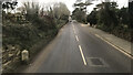
6
To Land's End
Milestone at Hayle, on a stretch of road which was formerly part of the A30.
Image: © Malcolm Kewn
Taken: 16 Jun 2009
0.17 miles
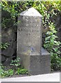
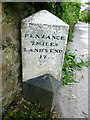
7
Old Milestone by the B3301, west of Hayle
Carved stone post by the B3301, in parish of HAYLE (PENWITH District), Carnsew Road, in front of ornamental gardens, on road edge below stone wall, on South side of road. Hayle facets, erected by the Hayle Bridge Causeway turnpike trust in the 19th century.
Inscription reads:-
: PENZANCE / 7 / LANDS END 17 : : HAYLE / 1 MILE / CAMBORNE / 7 / REDRUTH / 10 / TRURO / 19 :
Carved bench mark on base.
Grade II Listed. List Entry Number: 1327586
https://historicengland.org.uk/listing/the-list/list-entry/1327586
Milestone Society National ID: CW_PZCA07.
Image: © Ian Thompson
Taken: 10 Dec 2017
0.18 miles
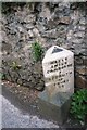
8
Old Milestone by the B3301, west of Hayle
Carved stone post by the B3301, in parish of HAYLE (PENWITH District), Carnsew Road, in front of ornamental gardens, on road edge below stone wall, on South side of road. Hayle facets, erected by the Hayle Bridge Causeway turnpike trust in the 19th century.
Inscription reads:-
: PENZANCE / 7 / LAND'S END / 17 : : HAYLE / 1 MILE / CAMBORNE / 7 / REDRUTH / 10 / TRURO / 19 :
Carved bench mark on lower front face.
Grade II listed.
List Entry Number: 1327586 https://historicengland.org.uk/listing/the-list/list-entry/1327586
Milestone Society National ID: CW_PZCA07.
Image: © Rosy Hanns
Taken: 31 May 2019
0.18 miles
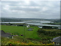
10
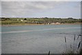
Across the estuary
View from Lelant station across the water with the tide in. Spot the Penzance to Paddington train on Hayle causeway.
Image: © roger geach
Taken: 15 May 2010
0.21 miles