IMAGES TAKEN NEAR TO
Tredrea Lane, HAYLE, TR27 6HD
Introduction
This page details the photographs taken nearby to Tredrea Lane, TR27 6HD by members of the Geograph project.
The Geograph project started in 2005 with the aim of publishing, organising and preserving representative images for every square kilometre of Great Britain, Ireland and the Isle of Man.

There are currently over 7.5m images from over14,400 individuals and you can help contribute to the project by visiting https://www.geograph.org.uk
Image Map
Images are licensed for reuse under creativecommons.org/licenses/by-sa/2.0
Notes
- Clicking on the map will re-center to the selected point.
- The higher the marker number, the further away the image location is from the centre of the postcode.
Image Listing (9 Images Found)
Images are licensed for reuse under creativecommons.org/licenses/by-sa/2.0
Image
Details
Distance
1
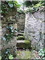
Stone Stile SW5434b
At the end of a field path from St Erth to Tredrea Manor, where it joins a small lane.
Curved coffen type, with six granite steps set in a curve through ninety degrees between high stone walls. One stone is broken.
Public footpath 111/1/1 gold from Little Mill Lane to Tredrea, at its junction with bridlepath 111/4/1 and 111/4/2 at Tredrea
Image: © Linda King
Taken: 20 Dec 2021
0.03 miles
2
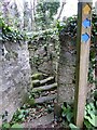
Stone Stile SW5434b
At the end of a field path from St Erth to Tredrea Manor, where it joins a small lane.
Curved coffen type, with six granite steps set in a curve through ninety degrees between high stone walls. One stone is broken.
Public footpath 111/1/1 gold from Little Mill Lane to Tredrea, at its junction with bridlepath 111/4/1 and 111/4/2 at Tredrea.
Image: © Linda King
Taken: 20 Dec 2021
0.03 miles
3
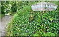
Bridleway towards Tredrea Manor
I had planned to come up this bridleway, but because of the rain I went along Tredrea Lane instead. So I have not seen the manor, only the driveway to it.
Image: © Graham Horn
Taken: 6 Jul 2011
0.06 miles
4
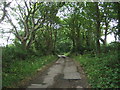
Track (bridleway) to Tredrea Manor
Looking south.
Image: © JThomas
Taken: 13 Jul 2017
0.07 miles
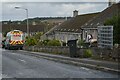
5
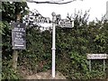
Direction Sign ? Signpost
Located on the south side of the Tredrear Lane junction with Treloweth Lane at the entrance to the village in St Erth parish. 3 arms and ball finial. See also https://www.flickr.com/photos/bridgemarkertim/12162272085.
Milestone Society National ID: CW_SW5435
Image: © L Dyer
Taken: 12 Jul 2019
0.21 miles
6
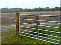
Farmland off Tredrea Lane
Very flat arable land here. Is this a crop of potatoes?
Image: © Graham Horn
Taken: 6 Jul 2011
0.24 miles
7
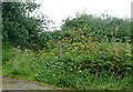
Footpath to Arch Lane
There is a footpath sign here, but the start of the route looks very overgrown . I can't imagine that it is used very often. It is raining hard so it is not on my agenda today.
Image: © Graham Horn
Taken: 6 Jul 2011
0.24 miles
8
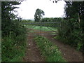
Field entrance and footpath off Tredrea Lane
Image: © JThomas
Taken: 13 Jul 2017
0.24 miles
9
St Erth : Treloweth Close
A residential road off Treloweth Lane.
Image: © Lewis Clarke
Taken: 28 Sep 2022
0.24 miles