IMAGES TAKEN NEAR TO
Bunkers Hill, HAYLE, TR27 6ER
Introduction
This page details the photographs taken nearby to Bunkers Hill, TR27 6ER by members of the Geograph project.
The Geograph project started in 2005 with the aim of publishing, organising and preserving representative images for every square kilometre of Great Britain, Ireland and the Isle of Man.

There are currently over 7.5m images from over14,400 individuals and you can help contribute to the project by visiting https://www.geograph.org.uk
Image Map
Images are licensed for reuse under creativecommons.org/licenses/by-sa/2.0
Notes
- Clicking on the map will re-center to the selected point.
- The higher the marker number, the further away the image location is from the centre of the postcode.
Image Listing (8 Images Found)
Images are licensed for reuse under creativecommons.org/licenses/by-sa/2.0
Image
Details
Distance
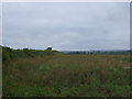
1
Fields of marrows at Mably
The building in the distance is the Country Skittle Park.
Image: © Sheila Russell
Taken: 14 Jun 2006
0.06 miles
2
Country skittles at Mably Farm
An interesting choice of farm diversification.
Image: © David Medcalf
Taken: 14 Sep 2021
0.06 miles
3
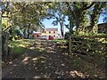
Bunkers Hill, Mably Farm
Looking south east.
Image: © JThomas
Taken: 12 Jul 2017
0.06 miles
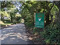
4
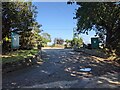
Welcome to Country Skittles!
Well enough established to feature on the OS 1:25k map.
Image: © David Medcalf
Taken: 14 Sep 2021
0.07 miles
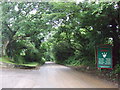
6
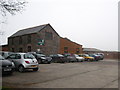
Converted barn at Country Skittles
Farm buildings at Mably Farm have been converted into an entertainment complex under the name of 'Country Skittles'.
Image: © Rod Allday
Taken: 30 Mar 2011
0.08 miles
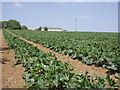
7
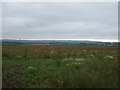
Crop field near Mably Farm
Off Bunkers Hill.
Image: © JThomas
Taken: 12 Jul 2017
0.14 miles