IMAGES TAKEN NEAR TO
Treven Lane, HAYLE, TR27 6EB
Introduction
This page details the photographs taken nearby to Treven Lane, TR27 6EB by members of the Geograph project.
The Geograph project started in 2005 with the aim of publishing, organising and preserving representative images for every square kilometre of Great Britain, Ireland and the Isle of Man.

There are currently over 7.5m images from over14,400 individuals and you can help contribute to the project by visiting https://www.geograph.org.uk
Image Map
Images are licensed for reuse under creativecommons.org/licenses/by-sa/2.0
Notes
- Clicking on the map will re-center to the selected point.
- The higher the marker number, the further away the image location is from the centre of the postcode.
Image Listing (11 Images Found)
Images are licensed for reuse under creativecommons.org/licenses/by-sa/2.0
Image
Details
Distance
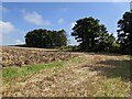
3
A wet field of sprouts
A very wet field of Brussels sprouts near Treven Farm to the south of St Erth Praze.
Image: © Philip Halling
Taken: 2 Jan 2014
0.09 miles
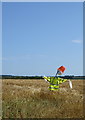
5
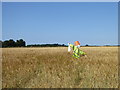
Scarecrow twin at Treven Farm
An identical one to the scarecrow in the adjacent field Image
Image: © Rod Allday
Taken: 13 Jul 2018
0.11 miles
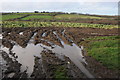
8
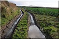
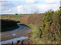
Wet and muddy track
Wet and muddy farmland track to the south of Treven Farm.
Image: © Philip Halling
Taken: 2 Jan 2014
0.16 miles
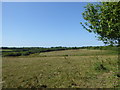
9
Scarecrow in a field of barley at Treven Farm
Image: © Rod Allday
Taken: 13 Jul 2018
0.16 miles