IMAGES TAKEN NEAR TO
Kirthen Wood, HAYLE, TR27 6AH
Introduction
This page details the photographs taken nearby to Kirthen Wood, TR27 6AH by members of the Geograph project.
The Geograph project started in 2005 with the aim of publishing, organising and preserving representative images for every square kilometre of Great Britain, Ireland and the Isle of Man.

There are currently over 7.5m images from over14,400 individuals and you can help contribute to the project by visiting https://www.geograph.org.uk
Image Map
Images are licensed for reuse under creativecommons.org/licenses/by-sa/2.0
Notes
- Clicking on the map will re-center to the selected point.
- The higher the marker number, the further away the image location is from the centre of the postcode.
Image Listing (9 Images Found)
Images are licensed for reuse under creativecommons.org/licenses/by-sa/2.0
Image
Details
Distance
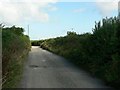
2
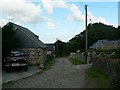
Kerthen Wood Farm
Looking more or less along the grid line - the buildings on the left are in Image
"Kerthen" is the correct spelling here, according to the name plate on the house out of sight to the right.
Image: © Rich Tea
Taken: 2 Aug 2006
0.08 miles
3
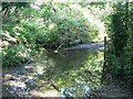
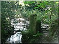
Ford by Kirthen Wood Haven
The spelling of Kirthen/Kerthen is variable! In this case Kirthen is correct according to a sign at the end of the lane.
Image: © Rich Tea
Taken: 2 Aug 2006
0.11 miles
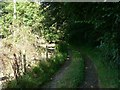
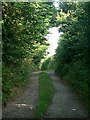
6
The bridleway near West Downs Farm
The trees have formed a green tunnel for the path.
Image: © David Medcalf
Taken: 14 Sep 2021
0.18 miles
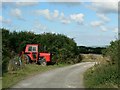
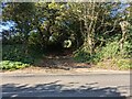
7
Lane to Kerthen Wood Farm
There are 2 farms with very similar names Kirthen and Kerthen, as is made clear by the signs at the ends of the lanes leading to them.
Image: © Rich Tea
Taken: 2 Aug 2006
0.21 miles
9
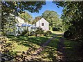
A house next to the bridleway near Townshend
Image: © David Medcalf
Taken: 14 Sep 2021
0.25 miles