IMAGES TAKEN NEAR TO
Townshend, HAYLE, TR27 6AE
Introduction
This page details the photographs taken nearby to TR27 6AE by members of the Geograph project.
The Geograph project started in 2005 with the aim of publishing, organising and preserving representative images for every square kilometre of Great Britain, Ireland and the Isle of Man.

There are currently over 7.5m images from over14,400 individuals and you can help contribute to the project by visiting https://www.geograph.org.uk
Image Map
Images are licensed for reuse under creativecommons.org/licenses/by-sa/2.0
Notes
- Clicking on the map will re-center to the selected point.
- The higher the marker number, the further away the image location is from the centre of the postcode.
Image Listing (5 Images Found)
Images are licensed for reuse under creativecommons.org/licenses/by-sa/2.0
Image
Details
Distance
1
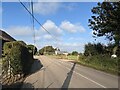
The B2380 at Little Kerthen
'Kerthen/Kerthin' is a common name in this area, with the two spellings used on different buildings.
Image: © David Medcalf
Taken: 14 Sep 2021
0.09 miles
2
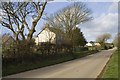
Dwellings at Paul's Green
Houses along the B3280 at Paul's Green.
Image: © Elizabeth Scott
Taken: 3 Mar 2012
0.11 miles
3
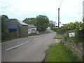
The B3280 at Paul's Green
Paul's Green Farm is on the left.
Image: © Rod Allday
Taken: 30 May 2013
0.12 miles
5
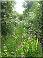
A little-used footpath at Paul's Green
Almost completely overgrown with wild flowers.
Image: © Rod Allday
Taken: 30 May 2013
0.21 miles