IMAGES TAKEN NEAR TO
Guildford Road, HAYLE, TR27 5HU
Introduction
This page details the photographs taken nearby to Guildford Road, TR27 5HU by members of the Geograph project.
The Geograph project started in 2005 with the aim of publishing, organising and preserving representative images for every square kilometre of Great Britain, Ireland and the Isle of Man.

There are currently over 7.5m images from over14,400 individuals and you can help contribute to the project by visiting https://www.geograph.org.uk
Image Map
Images are licensed for reuse under creativecommons.org/licenses/by-sa/2.0
Notes
- Clicking on the map will re-center to the selected point.
- The higher the marker number, the further away the image location is from the centre of the postcode.
Image Listing (23 Images Found)
Images are licensed for reuse under creativecommons.org/licenses/by-sa/2.0
Image
Details
Distance
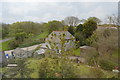
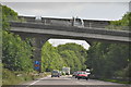
2

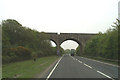
Road and railway bridges over A30
Near Ventonleague
Image: © John Firth
Taken: 13 Jun 2014
0.04 miles
3
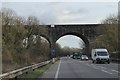
Railway bridge over A30 east of Hayle
The main line from Penzance to Paddington
Image: © David Smith
Taken: 11 Mar 2016
0.04 miles
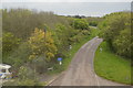
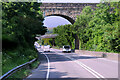
4
The A30 passes under the London-Penzance line
Near Angarrack on the Hayle by-pass.
Image: © David Long
Taken: 10 May 2006
0.04 miles
5
Cornish Mainline Railway crossing the A30 near Hayle
Image: © David Dixon
Taken: 6 Jun 2023
0.05 miles
6
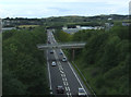
A30 east of Hayle
Overbridge carries Nanpusker Road (National Cycle Route 3).
Image: © JThomas
Taken: 10 Jul 2017
0.05 miles
7
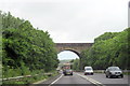
Penzance to Paddington Line Crosses the A30
Image: © Roy Hughes
Taken: 29 Jun 2012
0.06 miles
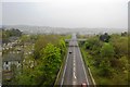
8
Ventonleague : The A30
The A30 near Ventonleague heading down towards Penzance from here. There is a rail bridge and a road bridge in view.
Image: © Lewis Clarke
Taken: 1 Jul 2011
0.06 miles