IMAGES TAKEN NEAR TO
Fraddam Road, HAYLE, TR27 5EW
Introduction
This page details the photographs taken nearby to Fraddam Road, TR27 5EW by members of the Geograph project.
The Geograph project started in 2005 with the aim of publishing, organising and preserving representative images for every square kilometre of Great Britain, Ireland and the Isle of Man.

There are currently over 7.5m images from over14,400 individuals and you can help contribute to the project by visiting https://www.geograph.org.uk
Image Map
Images are licensed for reuse under creativecommons.org/licenses/by-sa/2.0
Notes
- Clicking on the map will re-center to the selected point.
- The higher the marker number, the further away the image location is from the centre of the postcode.
Image Listing (11 Images Found)
Images are licensed for reuse under creativecommons.org/licenses/by-sa/2.0
Image
Details
Distance
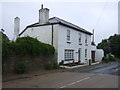
2
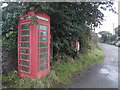
Fraddam: red telephone box
Situated on the crossroads, alongside a postbox (see Image).
Image: © Chris Downer
Taken: 17 Oct 2013
0.07 miles
3
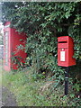
Fraddam: postbox № TR27 131
The postbox stands alongside Image, at the crossroads.
Image: © Chris Downer
Taken: 17 Oct 2013
0.07 miles
4
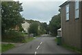
Gwinear-Gwithean : Deveral Road
Deveral Road off Fraddam Road.
Image: © Lewis Clarke
Taken: 29 Sep 2022
0.07 miles
5
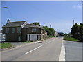
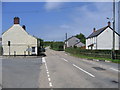
Fraddam Village looking east
Fraddam is a small village clustered around a crossroads. This view is looking east from the crossroads
Image: © Alan Simkins
Taken: 21 May 2006
0.08 miles
7
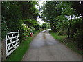
Byway towards Truthwell Farm
Off Fraddam Road.
Image: © JThomas
Taken: 11 Jul 2017
0.10 miles
9
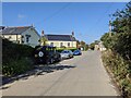
Fraddam Village looking west
Fraddam is a small village clustered around a crossroads. This view is looking west from the crossroads.vi
Image: © Alan Simkins
Taken: 21 May 2006
0.15 miles
10
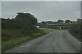
Crowan : Fraddam Road B3302
Looking along the B3302.
Image: © Lewis Clarke
Taken: 29 Sep 2022
0.16 miles