IMAGES TAKEN NEAR TO
The Anchorage, Riviere Towans, HAYLE, TR27 5DD
Introduction
This page details the photographs taken nearby to The Anchorage, Riviere Towans, TR27 5DD by members of the Geograph project.
The Geograph project started in 2005 with the aim of publishing, organising and preserving representative images for every square kilometre of Great Britain, Ireland and the Isle of Man.

There are currently over 7.5m images from over14,400 individuals and you can help contribute to the project by visiting https://www.geograph.org.uk
Image Map
Images are licensed for reuse under creativecommons.org/licenses/by-sa/2.0
Notes
- Clicking on the map will re-center to the selected point.
- The higher the marker number, the further away the image location is from the centre of the postcode.
Image Listing (40 Images Found)
Images are licensed for reuse under creativecommons.org/licenses/by-sa/2.0
Image
Details
Distance
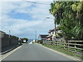
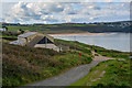
2
Phillack : Riviere Towans
Looking along a road.
Image: © Lewis Clarke
Taken: 22 Oct 2019
0.03 miles
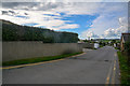
3
Phillack : Riviere Sands Holiday Park
A holiday park on the Cornish coastline.
Image: © Lewis Clarke
Taken: 22 Oct 2019
0.04 miles
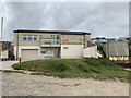
4
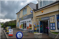
Phillack : Mini Market
A shop on Riviere Towans serving the nearby Haven.
Image: © Lewis Clarke
Taken: 22 Oct 2019
0.04 miles
5
Hayle : Footpath
A footpath heads down the hillside.
Image: © Lewis Clarke
Taken: 22 Oct 2019
0.08 miles

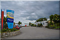
8
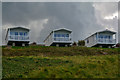
Hayle : Caravans
Looking towards caravans at the Haven Riviere Sands Holiday Park.
Image: © Lewis Clarke
Taken: 22 Oct 2019
0.13 miles
9
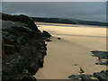
Black Cliff viewed towards the Hayle River
Image: © Peter Jemmett
Taken: 29 Aug 2008
0.14 miles
10
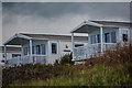
Hayle : Caravans
Caravans at the Haven Riviere Sands Holiday Park.
Image: © Lewis Clarke
Taken: 22 Oct 2019
0.14 miles