IMAGES TAKEN NEAR TO
Pentowan Road, HAYLE, TR27 5AR
Introduction
This page details the photographs taken nearby to Pentowan Road, TR27 5AR by members of the Geograph project.
The Geograph project started in 2005 with the aim of publishing, organising and preserving representative images for every square kilometre of Great Britain, Ireland and the Isle of Man.

There are currently over 7.5m images from over14,400 individuals and you can help contribute to the project by visiting https://www.geograph.org.uk
Image Map
Images are licensed for reuse under creativecommons.org/licenses/by-sa/2.0
Notes
- Clicking on the map will re-center to the selected point.
- The higher the marker number, the further away the image location is from the centre of the postcode.
Image Listing (34 Images Found)
Images are licensed for reuse under creativecommons.org/licenses/by-sa/2.0
Image
Details
Distance
1
Hayle : Melyn Close
Looking towards Loggan's Mill in Hayle.
Image: © Lewis Clarke
Taken: 2 Dec 2019
0.13 miles
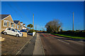
2
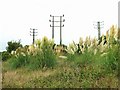
Pampas Grass under the powerlines
This pampas grass appears to be growing wild on the Hayle sand dunes, or perhaps this is an abandoned garden.
Image: © Tony Atkin
Taken: 24 Sep 2005
0.13 miles
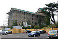
3
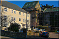
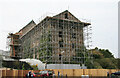
New affordable housing and a derelict Mill
The apartment block under construction is being built to be rented to local people, most of whom cannot afford to buy anywhere to live in the local area due to incomers being able to pay far higher prices than local people can afford. This is a common problem in many rural areas of Great Britain. The derelict industrial building behind is a reminder that Hayle was a leading industrial town in the 19th century.
Image: © Tony Atkin
Taken: 24 Sep 2005
0.13 miles
4
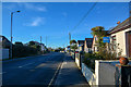
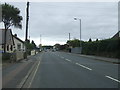
Hayle : Penmare Terrace B3301
A road heading into Hayle.
Image: © Lewis Clarke
Taken: 2 Dec 2019
0.14 miles
6
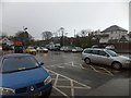
Lidl car park, Phillack
Part of the supermarket car park on a dark, rain-filled day.
Image: © David Smith
Taken: 16 Jan 2014
0.15 miles
7
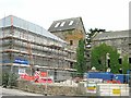
Loggans Mill, Copperhouse
A long derelict mill that was then surrounded with scaffolding and appeared to have received some work. It is Grade II Listed.
Image: © Chris Allen
Taken: 22 Sep 2008
0.15 miles
8
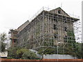
Loggan's Mill, Hayle
Loggan's Mill, was an early nineteenth century steam powered corn mill which was extended in 1852 and 1894. It was part of a larger industrial complex that was demolished in the 1980's. The mill building was Grade II listed in January 1988. Scaffolding went up in March 2006 to protect the structure.
Image: © Richard Rogerson
Taken: 23 Aug 2011
0.15 miles
9
Loggans Mill, Copperhouse
A Grade II Listed former flour mill that was swathed in scaffolding. I am not sure whether the situation has changed much since.
Image: © Chris Allen
Taken: 22 Sep 2008
0.15 miles
10
Hayle : Loggans Road B3301
Looking along the road heading out from Hayle.
Image: © Lewis Clarke
Taken: 2 Dec 2019
0.15 miles