IMAGES TAKEN NEAR TO
Lethlean Towans, HAYLE, TR27 5AP
Introduction
This page details the photographs taken nearby to Lethlean Towans, TR27 5AP by members of the Geograph project.
The Geograph project started in 2005 with the aim of publishing, organising and preserving representative images for every square kilometre of Great Britain, Ireland and the Isle of Man.

There are currently over 7.5m images from over14,400 individuals and you can help contribute to the project by visiting https://www.geograph.org.uk
Image Map
Images are licensed for reuse under creativecommons.org/licenses/by-sa/2.0
Notes
- Clicking on the map will re-center to the selected point.
- The higher the marker number, the further away the image location is from the centre of the postcode.
Image Listing (25 Images Found)
Images are licensed for reuse under creativecommons.org/licenses/by-sa/2.0
Image
Details
Distance
1
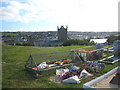
Phillack cemetery and church
The wire cages around the flowers on the recent graves have been placed by the funeral directors to prevent the large rabbit population from eating the flowers.
Image: © Rod Allday
Taken: 24 Sep 2009
0.18 miles
2
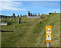
Phillack cemetery
The dread hand of Health & Safety even strikes here!
Image: © Rod Allday
Taken: 24 Sep 2009
0.18 miles
3
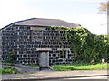
Slag Block Construction - Phillack Church Vestry
Built in 1805 by the Rev. William Hockin because it was cheaper than using quarried stone. The blocks were sold by the Cornish Copper Company based just across the estuary at Copperhouse at 9d (4p) a score. He bought several hundred blocks and made the churchyard walls, outhouses and the garden walls of the Rectory. He also built the Church School in Glebe Field, it was subsequently converted into a house which could cause problems as the blocks are impervious to air and moisture leading to a damp & cold dwelling.
Image: © Matthew Hatton
Taken: 5 Sep 2019
0.19 miles
4
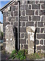
Old Wayside Cross
Wheal Alfred Cross, a wayside cross - moved, with an old head & shaft. Set in Phillack churchyard. Hayle parish. Langdon WC No. 80. Grade II Listed https://historicengland.org.uk/listing/the-list/list-entry/1143693. See also http://www.flickr.com/photos/ocifant/412921696.
Milestone Society National ID: CWPW_HAY02
Image: © L Nott
Taken: 17 Jun 2019
0.20 miles
5
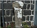
Two Ancient Stones
The one on the left is an Inscribed Stone, not that I could see any obvious carvings on it, and the one on the right it is a pre-Conquest wheel-headed wayside cross.
Image: © Matthew Hatton
Taken: 5 Sep 2019
0.20 miles
7
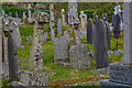
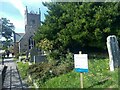
Phillack : St Felicitas and St Piala's Church - Graves
Graves in the churchyard.
Image: © Lewis Clarke
Taken: 22 Oct 2019
0.20 miles
8
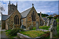
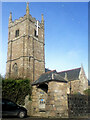
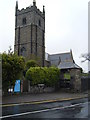
Phillack : St Felicitas and St Piala's Church
Image: © Lewis Clarke
Taken: 22 Oct 2019
0.21 miles