IMAGES TAKEN NEAR TO
Ellis Close, HAYLE, TR27 4SA
Introduction
This page details the photographs taken nearby to Ellis Close, TR27 4SA by members of the Geograph project.
The Geograph project started in 2005 with the aim of publishing, organising and preserving representative images for every square kilometre of Great Britain, Ireland and the Isle of Man.

There are currently over 7.5m images from over14,400 individuals and you can help contribute to the project by visiting https://www.geograph.org.uk
Image Map
Images are licensed for reuse under creativecommons.org/licenses/by-sa/2.0
Notes
- Clicking on the map will re-center to the selected point.
- The higher the marker number, the further away the image location is from the centre of the postcode.
Image Listing (64 Images Found)
Images are licensed for reuse under creativecommons.org/licenses/by-sa/2.0
Image
Details
Distance
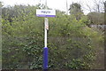
6
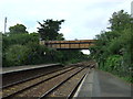
Bridge over railway near Hayle Railway Station
Image: © JThomas
Taken: 10 Jul 2017
0.14 miles
7
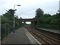
Footbridge near Hayle Railway Station
View north east from Platform 2.
Image: © JThomas
Taken: 14 Jul 2017
0.14 miles
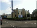
9
Hayle Methodist Church
The address of Chapel Hill suggests there was an earlier Methodist presence nearby.
Image: © John M
Taken: 9 Sep 2014
0.16 miles