IMAGES TAKEN NEAR TO
Mellanear Road, HAYLE, TR27 4QS
Introduction
This page details the photographs taken nearby to Mellanear Road, TR27 4QS by members of the Geograph project.
The Geograph project started in 2005 with the aim of publishing, organising and preserving representative images for every square kilometre of Great Britain, Ireland and the Isle of Man.

There are currently over 7.5m images from over14,400 individuals and you can help contribute to the project by visiting https://www.geograph.org.uk
Image Map
Images are licensed for reuse under creativecommons.org/licenses/by-sa/2.0
Notes
- Clicking on the map will re-center to the selected point.
- The higher the marker number, the further away the image location is from the centre of the postcode.
Image Listing (33 Images Found)
Images are licensed for reuse under creativecommons.org/licenses/by-sa/2.0
Image
Details
Distance
2
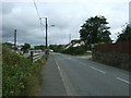
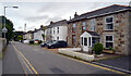
Mellanear Road, Hayle (B3302)
Looking south east.
Image: © JThomas
Taken: 10 Jul 2017
0.04 miles
3
B3302 Mellanear Road junction with Trelissick Road
Image: © Stuart Logan
Taken: 9 Oct 2012
0.05 miles
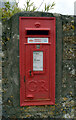
6
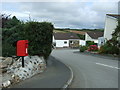
Elizabeth II postbox on Mellanear Road, Hayle
Postbox No. TR27 146.
See Image] for close up.
Image: © JThomas
Taken: 10 Jul 2017
0.07 miles
8
Post box, Trelissick Road, Hayle
This post box can be seen in context in Image
Image: © habiloid
Taken: 3 Sep 2020
0.10 miles
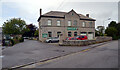
9
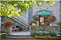
The Bird in Hand public house
The Bird in Hand Ahere's a colourful display of hanging baskets still remains, although we're almost at the end of the summer!
Image: © Mari Buckley
Taken: 15 Sep 2011
0.10 miles