IMAGES TAKEN NEAR TO
Millpond Avenue, HAYLE, TR27 4HX
Introduction
This page details the photographs taken nearby to Millpond Avenue, TR27 4HX by members of the Geograph project.
The Geograph project started in 2005 with the aim of publishing, organising and preserving representative images for every square kilometre of Great Britain, Ireland and the Isle of Man.

There are currently over 7.5m images from over14,400 individuals and you can help contribute to the project by visiting https://www.geograph.org.uk
Image Map
Images are licensed for reuse under creativecommons.org/licenses/by-sa/2.0
Notes
- Clicking on the map will re-center to the selected point.
- The higher the marker number, the further away the image location is from the centre of the postcode.
Image Listing (61 Images Found)
Images are licensed for reuse under creativecommons.org/licenses/by-sa/2.0
Image
Details
Distance
1
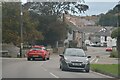
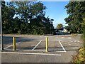
B3302 Mellanear Road junction with Trelissick Road
Image: © Stuart Logan
Taken: 9 Oct 2012
0.07 miles
2
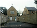
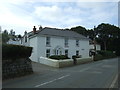
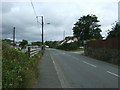
Foundry Hill, (B3302), Hayle
Looking south west up the hill.
Image: © JThomas
Taken: 10 Jul 2017
0.09 miles
4
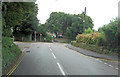
Hayle : Foundry Hill B3302
Looking along the road.
Image: © Lewis Clarke
Taken: 26 Sep 2022
0.10 miles
6
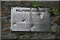
Plaque on industrial remains Hayle.
See Image This plaque is attached to the standing walls.
Image: © Chris Allen
Taken: 22 Sep 2008
0.11 miles
7
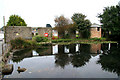
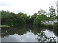
Mill pond and remains of Harveys works
The pond fed a hamer mill, boring mill and corn mill. The standing walls are the remains of the hammer mill. This was part of Harveys famous engineering works.
Image: © Chris Allen
Taken: 22 Sep 2008
0.11 miles
9
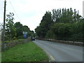
Mellanear Road, Hayle (B3302)
Looking south east.
Image: © JThomas
Taken: 10 Jul 2017
0.13 miles