IMAGES TAKEN NEAR TO
Trevoarn, Foundry Square, HAYLE, TR27 4HA
Introduction
This page details the photographs taken nearby to Trevoarn, Foundry Square, TR27 4HA by members of the Geograph project.
The Geograph project started in 2005 with the aim of publishing, organising and preserving representative images for every square kilometre of Great Britain, Ireland and the Isle of Man.

There are currently over 7.5m images from over14,400 individuals and you can help contribute to the project by visiting https://www.geograph.org.uk
Image Map
Images are licensed for reuse under creativecommons.org/licenses/by-sa/2.0
Notes
- Clicking on the map will re-center to the selected point.
- The higher the marker number, the further away the image location is from the centre of the postcode.
Image Listing (117 Images Found)
Images are licensed for reuse under creativecommons.org/licenses/by-sa/2.0
Image
Details
Distance
1
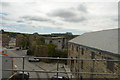
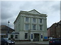
Foundry House, Hayle
Formerly the offices of the world famous engineering company Harveys. Best known for manufacturing Cornish beam engines, including some monstrous examples. This is the best preserved part of the works.
Image: © Chris Allen
Taken: 22 Sep 2008
0.01 miles
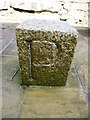
2
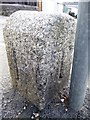
Old Boundary Marker
Estate Boundary Marker at the junction of Chapel Terrace and Foundry Hill, on the outer edge of the pavement by the entrance to the bakery. HAYLE parish. Inscribed P, P, P and T on its faces. P represents the Penpol Estate and T the Trelissick Estate.
Milestone Society National ID: CW_HAY01em
Image: © R Hanns
Taken: 29 Aug 2019
0.02 miles
3
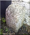
Old Boundary Marker
Estate Boundary Marker on the north side of Foundry Hill by the entrance to the bakery . HAYLE parish. Inscribed P, P, and T on its faces. P represents the Penpol Estate and T the Trelissick Estate.
Milestone Society National ID: CW_HAY03em
Image: © R Hanns
Taken: 29 Aug 2019
0.03 miles
5
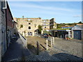
Harvey's Foundry
Some of the remains of the world famous foundry of Harvey & Co, best known for being manufacturers of Cornish beam engines, which were originally developed for draining the tin and copper mines. The company's offices are shown here Image The company was established in 1779 by John Harvey, went through a series of structural changes and mergers, and eventually closed the foundry part of the business in 1903. It continued to operate as a builders' merchant until the late 1960s.
The remains of the foundry were in a bad state of repair by the mid 1980s, at which point a number of local trusts, organisations and public bodies stepped in to conserve what was left. Post conversion, many of the buildings now serve as offices and craft workshops.
Image: © Richard Law
Taken: 19 Sep 2012
0.03 miles
6
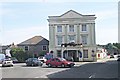
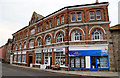
The White Hart Hotel, Hayle
The building to the left of the Hotel, now the Masonic Hall, was the original hotel building.
Image: © Tony Atkin
Taken: 8 Aug 2005
0.03 miles
7
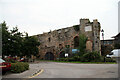
The remains of Harveys' Foundry, Hayle
Harveys was one of the major makers of mining machinery, including Cornish beam engines and this is part of their former works and is Listed Grade II.
Image: © Chris Allen
Taken: 22 Sep 2008
0.03 miles
8
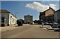
Hayle : Foundry Hill
From Carnsew Road looking up Foundry Hill in Hayle.
Image: © Lewis Clarke
Taken: 3 Jul 2011
0.04 miles
9
Old Boundary Marker
Estate Boundary Marker by the entrance to the White Hart Hotel on the south side of Foundry Hill. HAYLE parish. Inscribed P, P, P and T on its faces. P represents the Penpol Estate and T the Trelissick Estate.
Milestone Society National ID: CW_HAY04em
Image: © R Hanns
Taken: 29 Aug 2019
0.05 miles