IMAGES TAKEN NEAR TO
Burnthouse Lane, HAYLE, TR27 4AP
Introduction
This page details the photographs taken nearby to Burnthouse Lane, TR27 4AP by members of the Geograph project.
The Geograph project started in 2005 with the aim of publishing, organising and preserving representative images for every square kilometre of Great Britain, Ireland and the Isle of Man.

There are currently over 7.5m images from over14,400 individuals and you can help contribute to the project by visiting https://www.geograph.org.uk
Image Map
Images are licensed for reuse under creativecommons.org/licenses/by-sa/2.0
Notes
- Clicking on the map will re-center to the selected point.
- The higher the marker number, the further away the image location is from the centre of the postcode.
Image Listing (14 Images Found)
Images are licensed for reuse under creativecommons.org/licenses/by-sa/2.0
Image
Details
Distance
2
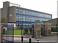
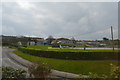
Hayle Community School
The striking blue coloured glass front of an otherwise drab three story block is mirrored in the colour of the gates and fence although this does not show up well in the photograph.
Image: © Tony Atkin
Taken: 24 Sep 2005
0.18 miles
3
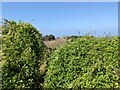
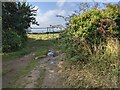
Overgrown access to the public footpath
It seems to be little used.
Image: © David Medcalf
Taken: 14 Sep 2021
0.18 miles
4
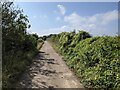
Bridleway above the A30
The A30 runs in a deep cutting behind the hedge on the left.
Image: © David Medcalf
Taken: 14 Sep 2021
0.20 miles
5

NEW
The A30 at Joppa, viewed from Strawberry Lane bridge
Image: © Rod Allday
Taken: 13 Mar 2025
0.22 miles
6
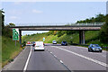
Bridge over the Hayle Bypass near High Lanes
Image: © David Dixon
Taken: 6 Jun 2023
0.22 miles
8

NEW
Strawberry Lane bridge over the A30 at Joppa
Image: © Rod Allday
Taken: 13 Mar 2025
0.22 miles
10
Field access from the bridleway
With an unusual farm gate, perhaps borrowed from a building site.
Image: © David Medcalf
Taken: 14 Sep 2021
0.22 miles