IMAGES TAKEN NEAR TO
Tolview Terrace, HAYLE, TR27 4AG
Introduction
This page details the photographs taken nearby to Tolview Terrace, TR27 4AG by members of the Geograph project.
The Geograph project started in 2005 with the aim of publishing, organising and preserving representative images for every square kilometre of Great Britain, Ireland and the Isle of Man.

There are currently over 7.5m images from over14,400 individuals and you can help contribute to the project by visiting https://www.geograph.org.uk
Image Map
Images are licensed for reuse under creativecommons.org/licenses/by-sa/2.0
Notes
- Clicking on the map will re-center to the selected point.
- The higher the marker number, the further away the image location is from the centre of the postcode.
Image Listing (101 Images Found)
Images are licensed for reuse under creativecommons.org/licenses/by-sa/2.0
Image
Details
Distance
1
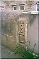
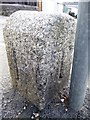
Old Milestone in Penpol Road, Hayle
Carved stone post by the B3302, in parish of HAYLE (PENWITH District), Penpol Road, in garden wall of No.3, NOT Penpol AVENUE, on North side of road. Erected by the parish in the 18th century.
Inscription reads:-
18
L
Grade II Listed. List Entry Number: 1143663
https://historicengland.org.uk/listing/the-list/list-entry/1143663
Milestone Society National ID: CW_PZL08.
Image: © Ian Thompson
Taken: 10 Dec 2017
0.04 miles
2
Old Milestone in Penpol Road, Hayle
Carved stone post east of the B3302, in parish of HAYLE (PENWITH District), Penpol Road, in garden wall of No.3, Penpol Road, on North side of road. Erected by the parish in the 18th century.
Inscription reads:-
18
L
Grade II listed.
List Entry Number: 1143663 https://historicengland.org.uk/listing/the-list/list-entry/1143663
Milestone Society National ID: CW_PZL08.
Image: © Rosy Hanns
Taken: 31 May 2019
0.04 miles
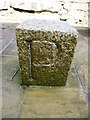
3
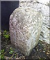
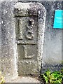
Old Boundary Marker
Estate Boundary Marker on the north side of Foundry Hill by the entrance to the bakery . HAYLE parish. Inscribed P, P, and T on its faces. P represents the Penpol Estate and T the Trelissick Estate.
Milestone Society National ID: CW_HAY03em
Image: © R Hanns
Taken: 29 Aug 2019
0.04 miles
4
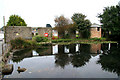
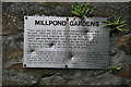
Mill pond and remains of Harveys works
The pond fed a hamer mill, boring mill and corn mill. The standing walls are the remains of the hammer mill. This was part of Harveys famous engineering works.
Image: © Chris Allen
Taken: 22 Sep 2008
0.05 miles
5
Plaque on industrial remains Hayle.
See Image This plaque is attached to the standing walls.
Image: © Chris Allen
Taken: 22 Sep 2008
0.05 miles
6
Old Boundary Marker
Estate Boundary Marker at the junction of Chapel Terrace and Foundry Hill, on the outer edge of the pavement by the entrance to the bakery. HAYLE parish. Inscribed P, P, P and T on its faces. P represents the Penpol Estate and T the Trelissick Estate.
Milestone Society National ID: CW_HAY01em
Image: © R Hanns
Taken: 29 Aug 2019
0.05 miles
8
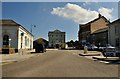
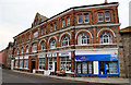
Hayle : Foundry Hill
From Carnsew Road looking up Foundry Hill in Hayle.
Image: © Lewis Clarke
Taken: 3 Jul 2011
0.08 miles
9
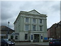
Foundry House, Hayle
Formerly the offices of the world famous engineering company Harveys. Best known for manufacturing Cornish beam engines, including some monstrous examples. This is the best preserved part of the works.
Image: © Chris Allen
Taken: 22 Sep 2008
0.08 miles
10
Old Boundary Marker
Estate Boundary Marker by the entrance to the White Hart Hotel on the south side of Foundry Hill. HAYLE parish. Inscribed P, P, P and T on its faces. P represents the Penpol Estate and T the Trelissick Estate.
Milestone Society National ID: CW_HAY04em
Image: © R Hanns
Taken: 29 Aug 2019
0.08 miles