IMAGES TAKEN NEAR TO
Halsetown, ST. IVES, TR26 3LZ
Introduction
This page details the photographs taken nearby to TR26 3LZ by members of the Geograph project.
The Geograph project started in 2005 with the aim of publishing, organising and preserving representative images for every square kilometre of Great Britain, Ireland and the Isle of Man.

There are currently over 7.5m images from over14,400 individuals and you can help contribute to the project by visiting https://www.geograph.org.uk
Image Map
Images are licensed for reuse under creativecommons.org/licenses/by-sa/2.0
Notes
- Clicking on the map will re-center to the selected point.
- The higher the marker number, the further away the image location is from the centre of the postcode.
Image Listing (7 Images Found)
Images are licensed for reuse under creativecommons.org/licenses/by-sa/2.0
Image
Details
Distance
1
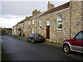
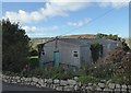
Old school house and cottages at Halsetown
Halsetown still has a Post Office, shop and pub. The school house and chapel have been converted. There is a camp site on the edge of the village.
Image: © Sheila Russell
Taken: 18 Jan 2006
0.09 miles
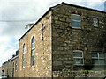
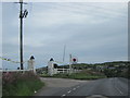
3
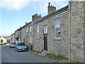
Terraced cottages in Halsetown
The nearest cottage is the old school.
Image: © Rod Allday
Taken: 8 Oct 2015
0.16 miles
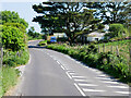
7
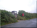
Connecting with the outside world
This 'phone kiosk and postbox are strategically placed between the local pub & a nearby campsite.
Image: © Row17
Taken: 29 Jul 2008
0.23 miles