IMAGES TAKEN NEAR TO
Lelant Meadows, ST. IVES, TR26 3JS
Introduction
This page details the photographs taken nearby to Lelant Meadows, TR26 3JS by members of the Geograph project.
The Geograph project started in 2005 with the aim of publishing, organising and preserving representative images for every square kilometre of Great Britain, Ireland and the Isle of Man.

There are currently over 7.5m images from over14,400 individuals and you can help contribute to the project by visiting https://www.geograph.org.uk
Image Map
Images are licensed for reuse under creativecommons.org/licenses/by-sa/2.0
Notes
- Clicking on the map will re-center to the selected point.
- The higher the marker number, the further away the image location is from the centre of the postcode.
Image Listing (33 Images Found)
Images are licensed for reuse under creativecommons.org/licenses/by-sa/2.0
Image
Details
Distance
1
Church Road, Lelant
Looking from upstairs in the Badger Inn.
Image: © Robin Webster
Taken: 17 May 2013
0.04 miles
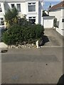
2
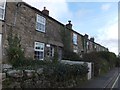
A terrace of stone houses, Lelant
Each has a small front garden, bounded by a stone wall
Image: © David Smith
Taken: 17 Jan 2014
0.05 miles
3
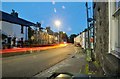
Lelant : Tyringham Place
Tyringham Place in Lelant with the lights of car headlights streaming through.
Image: © Lewis Clarke
Taken: 2 Jul 2011
0.06 miles
4
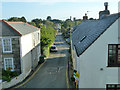
Lelant junction of the A3074 Tyringham Road and Church Road
Image: © Martin Dawes
Taken: 16 Jul 2017
0.06 miles
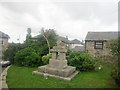
5
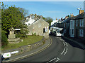
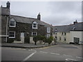
Corner by war memorial, Lelant
A route 14 bus is heading for Truro.
Image: © Robin Webster
Taken: 17 May 2013
0.07 miles
7
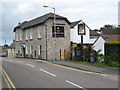
The Badger Inn, Lelant
Inn on the side of the A3074 in Lelant.
Image: © Philip Halling
Taken: 26 Apr 2010
0.13 miles
8
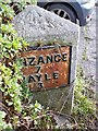
Old Milestone by A3074, Lelant
The Milestone is located in lay-by in corner of house wall on the North of the road. Parish of St Ives (Penwith District). Metal plate attached to stone post, erected by the Local Highways Board in the 19th Century. An earlier photograph can be found here: https://www.geograph.org.uk/photo/5623521
Inscription reads:-
PENZANCE / 7 / HAYLE / 3 : : St IVES / 3
Milestone Society National ID: CW_PZSI07
Image: © Paul Barnett
Taken: 9 Jul 2023
0.13 miles
9
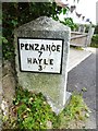
Old Milestone by the A3074, north west of Lelant
Metal plate attached to stone post by the A3074, in parish of ST IVES (PENWITH District), Lelant, in lay-by in corner of house wall, on North side of road. Erected by the Local Highways Board in the 19th century.
Inscription reads:-
: PENZANCE / 7 / HAYLE / 3 : : St IVES / 3 :
Milestone Society National ID: CW_PZSI07.
Image: © Ian Thompson
Taken: 10 Dec 2017
0.13 miles
10
Old Milestone by the A3074, Tyringham Road, Lelant
Metal plates attached to stone post by the A3074, in parish of ST IVES (PENWITH District), Lelant, in lay-by in corner of house wall, on North side of road. Erected by the Local Highways Board in the 19th century.
Inscription reads:-
: PENZANCE / 7 / HAYLE / 3 : : St IVES / 3 :
Cornwall & Scilly HER.
HER Number: 178443 https://www.heritagegateway.org.uk/Gateway/Results_Single.aspx?uid=MCO54219&resourceID=1020
Milestone Society National ID: CW_PZSI07.
Image: © Rosy Hanns
Taken: 1 Jun 2019
0.13 miles