IMAGES TAKEN NEAR TO
Trink, ST. IVES, TR26 3JG
Introduction
This page details the photographs taken nearby to TR26 3JG by members of the Geograph project.
The Geograph project started in 2005 with the aim of publishing, organising and preserving representative images for every square kilometre of Great Britain, Ireland and the Isle of Man.

There are currently over 7.5m images from over14,400 individuals and you can help contribute to the project by visiting https://www.geograph.org.uk
Image Map
Images are licensed for reuse under creativecommons.org/licenses/by-sa/2.0
Notes
- Clicking on the map will re-center to the selected point.
- The higher the marker number, the further away the image location is from the centre of the postcode.
Image Listing (7 Images Found)
Images are licensed for reuse under creativecommons.org/licenses/by-sa/2.0
Image
Details
Distance
2
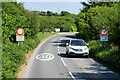
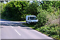
Trevarrack : Road
A road heads through the countryside.
Image: © Lewis Clarke
Taken: 29 Sep 2022
0.19 miles
3
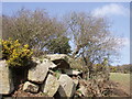
Gate and gorse
Typical granite boulders at the edge of the field gate. Looking north east from Nance.
Image: © Sheila Russell
Taken: 19 Mar 2006
0.20 miles
5
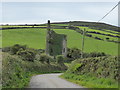
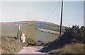
Wheal Sisters engine house
The ivy has grown significantly since 1985 - see: http://www.geograph.org.uk/photo/2800580
Image: © David Medcalf
Taken: 7 Sep 2013
0.24 miles
6
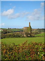
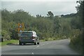
Engine house at Wheal Alice
Near the hamlet of Trencrom.
Image: © Rod Allday
Taken: 6 Oct 2010
0.25 miles