IMAGES TAKEN NEAR TO
Balnoon, ST. IVES, TR26 3JA
Introduction
This page details the photographs taken nearby to Balnoon, TR26 3JA by members of the Geograph project.
The Geograph project started in 2005 with the aim of publishing, organising and preserving representative images for every square kilometre of Great Britain, Ireland and the Isle of Man.

There are currently over 7.5m images from over14,400 individuals and you can help contribute to the project by visiting https://www.geograph.org.uk
Image Map
Images are licensed for reuse under creativecommons.org/licenses/by-sa/2.0
Notes
- Clicking on the map will re-center to the selected point.
- The higher the marker number, the further away the image location is from the centre of the postcode.
Image Listing (7 Images Found)
Images are licensed for reuse under creativecommons.org/licenses/by-sa/2.0
Image
Details
Distance
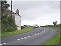
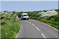
1
Halsetown : Balnoon Road
A road taken from the junction.
Image: © Lewis Clarke
Taken: 29 Sep 2022
0.12 miles
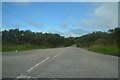
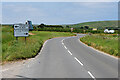
3
Halsetown : Road
A road heading through the countryside.
Image: © Lewis Clarke
Taken: 29 Sep 2022
0.15 miles
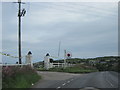
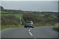
7
Unnamed Road approaching Junction with the B3311
Image: © David Dixon
Taken: 6 Jun 2023
0.24 miles