IMAGES TAKEN NEAR TO
Lelant, ST. IVES, TR26 3HU
Introduction
This page details the photographs taken nearby to TR26 3HU by members of the Geograph project.
The Geograph project started in 2005 with the aim of publishing, organising and preserving representative images for every square kilometre of Great Britain, Ireland and the Isle of Man.

There are currently over 7.5m images from over14,400 individuals and you can help contribute to the project by visiting https://www.geograph.org.uk
Image Map
Images are licensed for reuse under creativecommons.org/licenses/by-sa/2.0
Notes
- Clicking on the map will re-center to the selected point.
- The higher the marker number, the further away the image location is from the centre of the postcode.
Image Listing (3 Images Found)
Images are licensed for reuse under creativecommons.org/licenses/by-sa/2.0
Image
Details
Distance
1
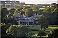
Trevethoe : Big House
A house in a small village called Trevethoe. This was taken from a road near Lelant.
Image: © Lewis Clarke
Taken: 2 Jul 2011
0.04 miles
2

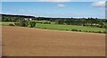
Trevethoe Barton : Farm Buildings
From St Ives Road looking across to Trevethoe Barton and farm buildings.
Image: © Lewis Clarke
Taken: 2 Jul 2011
0.09 miles