IMAGES TAKEN NEAR TO
Laity Lane, ST. IVES, TR26 3HP
Introduction
This page details the photographs taken nearby to Laity Lane, TR26 3HP by members of the Geograph project.
The Geograph project started in 2005 with the aim of publishing, organising and preserving representative images for every square kilometre of Great Britain, Ireland and the Isle of Man.

There are currently over 7.5m images from over14,400 individuals and you can help contribute to the project by visiting https://www.geograph.org.uk
Image Map
Images are licensed for reuse under creativecommons.org/licenses/by-sa/2.0
Notes
- Clicking on the map will re-center to the selected point.
- The higher the marker number, the further away the image location is from the centre of the postcode.
Image Listing (7 Images Found)
Images are licensed for reuse under creativecommons.org/licenses/by-sa/2.0
Image
Details
Distance
1
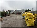
New houses above Carbis Bay
A development of 3 large houses, being built just off Laity Lane above Carbis Bay
Image: © Richard Law
Taken: 25 Dec 2021
0.12 miles
2
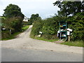
Across the holiday park
The footpath, part of St Michael's Way, crosses this holiday park, effectively a caravan site. Here is one of the water points and the toilet/shower block. But no caravans or tents.
Image: © Graham Horn
Taken: 2 Jul 2011
0.13 miles
3
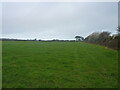
Field on the western side of Carbis Bay
Image: © Richard Law
Taken: 24 Dec 2021
0.18 miles
4
It's bin day at Venwyn
See http://www.geograph.org.uk/photo/2512272
Image: © David Medcalf
Taken: 4 Sep 2015
0.21 miles
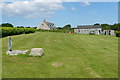
5
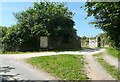
Entrance to Venwyn
A property in the north-east corner of the square.
Image: © Graham Horn
Taken: 2 Jul 2011
0.21 miles
6
Fresh vegetables at Trenance Withen Farm
Image: © David Medcalf
Taken: 4 Sep 2015
0.22 miles
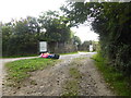
7
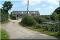
Footpath at Withen
The footpath goes to the left of this barn, part of the Withen group of farm buildings.
Image: © Graham Horn
Taken: 2 Jul 2011
0.22 miles