IMAGES TAKEN NEAR TO
Lelant, ST. IVES, TR26 3EY
Introduction
This page details the photographs taken nearby to TR26 3EY by members of the Geograph project.
The Geograph project started in 2005 with the aim of publishing, organising and preserving representative images for every square kilometre of Great Britain, Ireland and the Isle of Man.

There are currently over 7.5m images from over14,400 individuals and you can help contribute to the project by visiting https://www.geograph.org.uk
Image Map
Images are licensed for reuse under creativecommons.org/licenses/by-sa/2.0
Notes
- Clicking on the map will re-center to the selected point.
- The higher the marker number, the further away the image location is from the centre of the postcode.
Image Listing (16 Images Found)
Images are licensed for reuse under creativecommons.org/licenses/by-sa/2.0
Image
Details
Distance
1
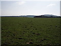
Over the Valley
Looking over the valley northeast of Trencrom Hill.
Image: © Tony Atkin
Taken: 28 Aug 2007
0.07 miles
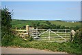
2
On St Michael's Way
The way comes out of a covered footpath into open farmland here, near Beersheba. The route is from St Michael's Mount to St Ives and is marketed as part of a longer trail, the pilgrims' trail to Santiago de Compostela in Northern Spain.
Image: © Graham Horn
Taken: 2 Jul 2011
0.11 miles
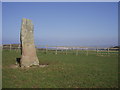
3
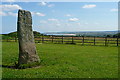
Beersheba standing stone
An impressive 10' high menhir also known as the Longstone.
Image: © Rod Allday
Taken: 1 Dec 2012
0.12 miles
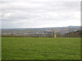
4
Standing stone on St Michael's Way
Looking north east, with Carbis Bay and Hayle Towans beyond.
Image: © Sheila Russell
Taken: 19 Mar 2006
0.13 miles
5
Standing stone at Beersheba
One of many such stones in this ancient landscape, this was probably erected in the bronze age, 3,000 years ago. It overlooks the Hayle estuary and St Ives Bay.
Image: © Graham Horn
Taken: 2 Jul 2011
0.15 miles
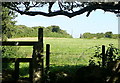
6
Sheep grazing
The field was formerly used for daffodils; this year the sheep have had a good feed on the daffodil leaves.
Image: © Sheila Russell
Taken: 19 Mar 2006
0.15 miles
7
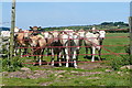
Cattle at Beersheba
These heifers we interested to see me. Fortunately the footpath stays this side of the gate. I think I would have had difficulty getting past them on the other side.
Image: © Graham Horn
Taken: 2 Jul 2011
0.16 miles
8
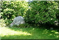
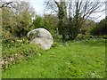
The Bowl Rock
The story goes that it is one of the stones used by the giants playing a game of bowls from the nearby Trencrom Hill. In reality it is a granite outlier. It is cared for by The National Trust. How do you care for a rock?
Image: © Graham Horn
Taken: 2 Jul 2011
0.16 miles
9
The Bowl Rock - cleaned up
The Rock has had a haircut sometime in the last ten years. See: http://www.geograph.org.uk/photo/107859
Image: © David Medcalf
Taken: 24 Apr 2017
0.16 miles
10
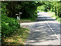
Unnamed Road, Lelant Downs
Minor road near St Ives.
Image: © David Dixon
Taken: 6 Jun 2023
0.18 miles