IMAGES TAKEN NEAR TO
Mount Pleasant, ST. IVES, TR26 3ED
Introduction
This page details the photographs taken nearby to Mount Pleasant, TR26 3ED by members of the Geograph project.
The Geograph project started in 2005 with the aim of publishing, organising and preserving representative images for every square kilometre of Great Britain, Ireland and the Isle of Man.

There are currently over 7.5m images from over14,400 individuals and you can help contribute to the project by visiting https://www.geograph.org.uk
Image Map
Images are licensed for reuse under creativecommons.org/licenses/by-sa/2.0
Notes
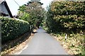
- Clicking on the map will re-center to the selected point.
- The higher the marker number, the further away the image location is from the centre of the postcode.
Image Listing (41 Images Found)
Images are licensed for reuse under creativecommons.org/licenses/by-sa/2.0
Image
Details
Distance
1
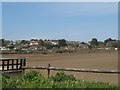
View of Lelant - Hayle Estuary
A train had just run along the line between the estuary and the houses on its way to Lelant Saltings Station further to the left. There was not much greenery apparent in the estuary after the long hard winter but we did see an oystercatcher.
Image: © Sarah Smith
Taken: 11 Apr 2010
0.04 miles
2
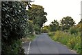
Lelant : The Saltings
A road which is close to the Hayle Estuary and provides access to housing.
Image: © Lewis Clarke
Taken: 2 Jul 2011
0.10 miles
3
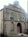
Lelant Wesleyan church
Recently converted to a house
Image: © Paul Barnett
Taken: 25 Oct 2015
0.11 miles
4
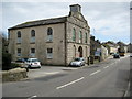
Wesleyan Chapel, Lelant
This Wesleyan chapel in Lelant was built in 1834.
Image: © Philip Halling
Taken: 26 Apr 2010
0.11 miles
5
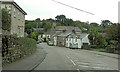
A3074 passes listed buildings in Lelant
Boundy's House, with other listed buildings along the right hand side of the main road, form a village group. They are all Grade II listed from the 18th C cottages to the 19th C Wesleyan Chapel. See also Blue Door & The Cottage 1&2 : http://www.britishlistedbuildings.co.uk/england/cornwall/st+ives
Image: © Stuart Logan
Taken: 9 Oct 2012
0.11 miles
6
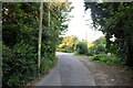
Lelant : The Saltings
The Saltings is a minor road which runs alongside the Hayle Estuary.
Image: © Lewis Clarke
Taken: 2 Jul 2011
0.14 miles
7
Seagulls at Lelant Saltings
Seagulls swoop above the saltings. The St. Erth to St. Ives railway line can be seen across the estuary.
Image: © Mari Buckley
Taken: Unknown
0.15 miles
8
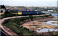
From Lelant Saltings, 1981
Similar position and direction from the first Geograph for this grid square, with narrower angle. "The Towans" in the background
Image: © Crispin Purdye
Taken: Unknown
0.15 miles
9
On the Back Road at Lelant
If you are walking the coast path from Hayle then by the time you reach Lelant you are probably going to be extremely tired of traffic and noise. Don't forget then to take the first turning right in Lelant and get on this quiet back road rather than the busy main road.
Image: © Tony Atkin
Taken: 6 Oct 2007
0.16 miles
10
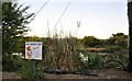
Lelant : Lelant Saltings Nature Reserve
A sign beside one of the small ponds which says Mrs Baggit wants people to take their litter home.
Image: © Lewis Clarke
Taken: 2 Jul 2011
0.16 miles