IMAGES TAKEN NEAR TO
Riverside, ST. IVES, TR26 3DW
Introduction
This page details the photographs taken nearby to Riverside, TR26 3DW by members of the Geograph project.
The Geograph project started in 2005 with the aim of publishing, organising and preserving representative images for every square kilometre of Great Britain, Ireland and the Isle of Man.

There are currently over 7.5m images from over14,400 individuals and you can help contribute to the project by visiting https://www.geograph.org.uk
Image Map
Images are licensed for reuse under creativecommons.org/licenses/by-sa/2.0
Notes
- Clicking on the map will re-center to the selected point.
- The higher the marker number, the further away the image location is from the centre of the postcode.
Image Listing (37 Images Found)
Images are licensed for reuse under creativecommons.org/licenses/by-sa/2.0
Image
Details
Distance
1
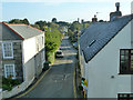
Church Road, Lelant
Looking from upstairs in the Badger Inn.
Image: © Robin Webster
Taken: 17 May 2013
0.05 miles
2
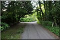
Lelant : The Saltings
A road along the estuary which then heads up towards Church Road.
Image: © Lewis Clarke
Taken: 2 Jul 2011
0.06 miles
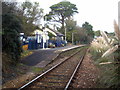
3
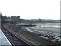
Railway at Lelant
Looking north east from Lelant station
Image: © Bob Jones
Taken: 1 Jan 2003
0.06 miles
5
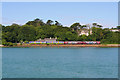
Lelant Halt
Passenger train at Lelant.
Image: © Wayland Smith
Taken: 7 Jun 2008
0.07 miles
7
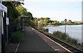
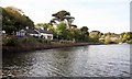
Lelant Station
On the St Ives branch line, the view is much better when the tide is in.
Image: © roger geach
Taken: 15 May 2010
0.07 miles
8
Lelant railway station
Overlooking the Hayle Estuary.
Image: © Bill Boaden
Taken: 6 Jul 2014
0.08 miles
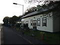
9
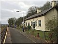
Lelant railway station
The former station building at Lelant.
Image: © Andrew Abbott
Taken: 19 Nov 2017
0.08 miles
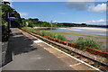
10
Lelant Station
On the picturesque St Ives Bay line.
Image: © Rod Allday
Taken: 1 Dec 2012
0.08 miles