IMAGES TAKEN NEAR TO
Zennor, ST. IVES, TR26 3BU
Introduction
This page details the photographs taken nearby to TR26 3BU by members of the Geograph project.
The Geograph project started in 2005 with the aim of publishing, organising and preserving representative images for every square kilometre of Great Britain, Ireland and the Isle of Man.

There are currently over 7.5m images from over14,400 individuals and you can help contribute to the project by visiting https://www.geograph.org.uk
Image Map
Images are licensed for reuse under creativecommons.org/licenses/by-sa/2.0
Notes
- Clicking on the map will re-center to the selected point.
- The higher the marker number, the further away the image location is from the centre of the postcode.
Image Listing (3 Images Found)
Images are licensed for reuse under creativecommons.org/licenses/by-sa/2.0
Image
Details
Distance
1
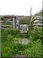
Stone Stile SW4637a
: On a footpath at the back of the farm, coming from the heathland. The footpath crosses through the farm and continues down a small access drive to the B3306 at Zennor.
Cattle stile beside farm gate.
Public footpath 120/4/1 gold from heathland to Zennor churchtown.
Image: © Linda King
Taken: 14 Jun 2021
0.04 miles
2
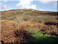
Zennor hill above the Foage valley
Crags on the south west side of Zennor Hill. Taken from the track to Foage farm.
Image: © Sheila Russell
Taken: 5 Dec 2005
0.16 miles
3
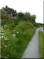
Stone Stile SW4637b
On an access drive to Rosemorran and Foage Farm, from its junction with the B3306 at Zennor. About halfway between the two properties a footpath rises left from the drive, heading steeply north to Zennor Hill. A marker stone indicates the path leads to Zennor Hill and the quoit.
Granite steps.
Footpath from access drive to public footpath 120/4/1 gold.
Image: © Linda King
Taken: 14 Jun 2021
0.24 miles