IMAGES TAKEN NEAR TO
Zennor, ST. IVES, TR26 3BP
Introduction
This page details the photographs taken nearby to TR26 3BP by members of the Geograph project.
The Geograph project started in 2005 with the aim of publishing, organising and preserving representative images for every square kilometre of Great Britain, Ireland and the Isle of Man.

There are currently over 7.5m images from over14,400 individuals and you can help contribute to the project by visiting https://www.geograph.org.uk
Image Map
Images are licensed for reuse under creativecommons.org/licenses/by-sa/2.0
Notes
- Clicking on the map will re-center to the selected point.
- The higher the marker number, the further away the image location is from the centre of the postcode.
Image Listing (21 Images Found)
Images are licensed for reuse under creativecommons.org/licenses/by-sa/2.0
Image
Details
Distance
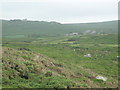
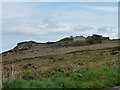
2

Lower Tregerthen
Part of the complex of farm buildings at Lower Tregerthen, one of the farms passed on the inland footpath route from St Ives to Zennor.
Image: © Graham Horn
Taken: 3 Jul 2011
0.08 miles
3
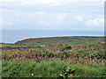
View from near Tregerthen
The view is east of south towards a unnamed hill, between Zennor Hill and Trendrine Hill in Image Close to hand we are on the inland footpath between St Ives and Zennor, crossing a number of arable fields and pastures. There is an unidentified crop in this one.
Image: © Graham Horn
Taken: 3 Jul 2011
0.10 miles
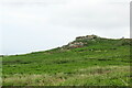
6
Higher Tregerthen
Wonderful views, but a bit exposed to the weather.
Image: © Robin Webster
Taken: 16 May 2013
0.16 miles
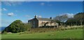
8
Large house beside the B3306 at Higher Tregerthen
With a commanding view of the coast.
Image: © Rod Allday
Taken: 12 Dec 2009
0.17 miles
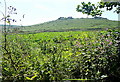
9
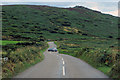
The B3306
High moorland at Zennor Hill.
Image: © Robert Ashby
Taken: 20 Aug 2014
0.18 miles
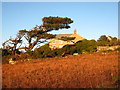
10
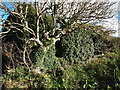
Ruined Chapel, Lower Tregerthen
Completely covered in ivy, possibly built by Methodists. (Not a barn as proposed elsewhere)
Image: © Chris Andrews
Taken: 27 Oct 2012
0.19 miles