IMAGES TAKEN NEAR TO
Towednack, ST. IVES, TR26 3AY
Introduction
This page details the photographs taken nearby to TR26 3AY by members of the Geograph project.
The Geograph project started in 2005 with the aim of publishing, organising and preserving representative images for every square kilometre of Great Britain, Ireland and the Isle of Man.

There are currently over 7.5m images from over14,400 individuals and you can help contribute to the project by visiting https://www.geograph.org.uk
Image Map
Images are licensed for reuse under creativecommons.org/licenses/by-sa/2.0
Notes
- Clicking on the map will re-center to the selected point.
- The higher the marker number, the further away the image location is from the centre of the postcode.
Image Listing (14 Images Found)
Images are licensed for reuse under creativecommons.org/licenses/by-sa/2.0
Image
Details
Distance
1
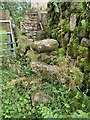
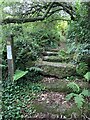
Stone Stile SW4838d
On a marked footpath across fields towards Beagletodn, where the footpath joins Beagletodn cottage.
Granite stile, quite disturbed, 27” across at the top tread, with the wall making up the right side, 8 feet in length across all treads and 27 “high.
Public footpath 119/11/1 silver from Towednack Church to Beagletodn
Image: © Sue Partington
Taken: 29 Jul 2021
0.01 miles
3
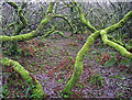
Scary wood near Amalveor
A patch of woodland to the west of the track to Beagletodn is low-lying; the twisted boughs are covered with a green lichen, giving the area an eerie feel.
Image: © Bob Jones
Taken: 1 Jan 2012
0.09 miles
4
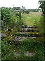
Stone Stile SW4838c
On a marked footpath across fields towards Beagletodn, after crossing the second field from Towednack Church.
Granite stile, now with some bracken growth and partly disturbed. The highest horizontal tread measures 4 feet across and is 18“high and 8 feet across all treads. Two treads lead up to the top one.
Public footpath 119/11/1 silver from Towednack Church to Beagletodn
Image: © Sue Partington
Taken: 29 Jul 2021
0.10 miles
5
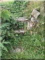
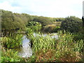
Stone Stile SW4837
It’s sited on the path east side of a small granite clapper bridge across the stream, on the footpath from Beagletodn, after the ponds leading towards the lane to Amalveor.
Coffen stile. It is 10 feet long, with horizontal treads and a suggestion of a pit under them. This stile is in good condition on a well-used path. It is 3 feet wide across the one slightly raised tread and 18” deep.
Public footpath 119/12/1 silver from Beagletodn to Amalveor
Image: © Sue Partington
Taken: 29 Jul 2021
0.14 miles
6
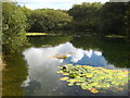
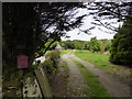
Pond at Amalveor
One of the ponds at Sweet Water Trout Farm http://www.sweetwater-bb.com/index.html.
Image: © Rod Allday
Taken: 6 Oct 2010
0.15 miles
7
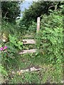
Cornish stile near Towednack
This is a typical Cornish stile, consisting of large pieces of granite separated by deep gaps that would trap any sheep or cow, and some humans. The footpath leads across pastures towards Towednack church.
Image: © Graham Horn
Taken: 6 Jul 2011
0.15 miles
8
One of the ponds at Sweet Water Trout Farm
The farm operates as a B & B and guests may fish in the ponds, one stocked with trout and one with carp http://www.sweetwater-bb.com/index.html.
Image: © Rod Allday
Taken: 6 Oct 2010
0.15 miles
9
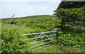
Gateway at Amalveor
This pasture is on the edge of open access land that leads towards Trendrine Hill Image seen on the horizon. However, access is difficult from this side.
Image: © Graham Horn
Taken: 6 Jul 2011
0.15 miles
10
Stone Stile SW4838b
On a marked footpath across fields towards Beagletodn, after crossing the first field from Towednack Church.
Granite, fairly good condition. 5 feet in width across the top tread, which is 30” high and the whole length is 12 feet. It consists of 3 treads leading up to 2, one above the other and 2 treads on the west side.
Public footpath 119/11/1 silver from Towednack Church to Beagletodn
Image: © Sue Partington
Taken: 29 Jul 2021
0.15 miles