IMAGES TAKEN NEAR TO
Halsetown Road, ST. IVES, TR26 3AQ
Introduction
This page details the photographs taken nearby to Halsetown Road, TR26 3AQ by members of the Geograph project.
The Geograph project started in 2005 with the aim of publishing, organising and preserving representative images for every square kilometre of Great Britain, Ireland and the Isle of Man.

There are currently over 7.5m images from over14,400 individuals and you can help contribute to the project by visiting https://www.geograph.org.uk
Image Map
Images are licensed for reuse under creativecommons.org/licenses/by-sa/2.0
Notes
- Clicking on the map will re-center to the selected point.
- The higher the marker number, the further away the image location is from the centre of the postcode.
Image Listing (30 Images Found)
Images are licensed for reuse under creativecommons.org/licenses/by-sa/2.0
Image
Details
Distance
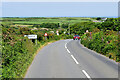
2
Towednack Road
Near the north end of Towednack Road.
Image: © Pierre Terre
Taken: 20 Jul 2008
0.06 miles
4
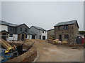
Building Site near Penbeagle - St Ives
New build homes with tradition stone work features. One home completely build with stone.
Image: © James Emmans
Taken: 28 May 2016
0.09 miles
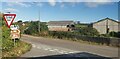
8
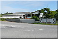
Consols Farm
Farm buildings north of a B-road junction to the west of St Ives.
Image: © Graham Horn
Taken: 6 Jul 2011
0.17 miles