IMAGES TAKEN NEAR TO
Towednack Road, ST. IVES, TR26 3AH
Introduction
This page details the photographs taken nearby to Towednack Road, TR26 3AH by members of the Geograph project.
The Geograph project started in 2005 with the aim of publishing, organising and preserving representative images for every square kilometre of Great Britain, Ireland and the Isle of Man.

There are currently over 7.5m images from over14,400 individuals and you can help contribute to the project by visiting https://www.geograph.org.uk
Image Map
Images are licensed for reuse under creativecommons.org/licenses/by-sa/2.0
Notes
- Clicking on the map will re-center to the selected point.
- The higher the marker number, the further away the image location is from the centre of the postcode.
Image Listing (28 Images Found)
Images are licensed for reuse under creativecommons.org/licenses/by-sa/2.0
Image
Details
Distance
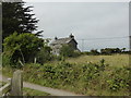
1
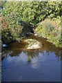
The Stennack River below Bussow Reservoir
Image: © Rod Allday
Taken: 8 Oct 2015
0.04 miles
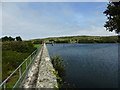
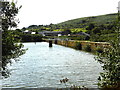
3
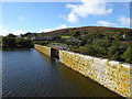
Looking west along the dam on Bussow Reservoir
Rosewall Hill is in the distance.
Image: © Rod Allday
Taken: 8 Oct 2015
0.05 miles
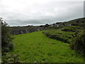
6
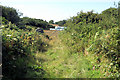
Fields by Stennack River
A field entrance by the Stennack River below Bussow Reservoir.
Image: © Pierre Terre
Taken: 20 Jul 2008
0.05 miles
8
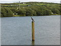
Two fishers - a cormorant and a man
The young cormorant is using the valve pipe as a resting place, whilst the man has a tent.
Image: © David Medcalf
Taken: 30 Aug 2013
0.07 miles
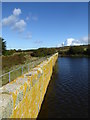
10
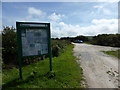
The car park at Bussow Reservoir
There are lots of instructions and prohibitions for anglers here.
Image: © David Medcalf
Taken: 30 Aug 2013
0.09 miles