IMAGES TAKEN NEAR TO
Pannier Lane, ST. IVES, TR26 2RQ
Introduction
This page details the photographs taken nearby to Pannier Lane, TR26 2RQ by members of the Geograph project.
The Geograph project started in 2005 with the aim of publishing, organising and preserving representative images for every square kilometre of Great Britain, Ireland and the Isle of Man.

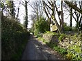
There are currently over 7.5m images from over14,400 individuals and you can help contribute to the project by visiting https://www.geograph.org.uk
Image Map
Images are licensed for reuse under creativecommons.org/licenses/by-sa/2.0
Notes
- Clicking on the map will re-center to the selected point.
- The higher the marker number, the further away the image location is from the centre of the postcode.
Image Listing (49 Images Found)
Images are licensed for reuse under creativecommons.org/licenses/by-sa/2.0
Image
Details
Distance
1
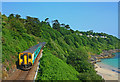
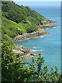
Barrepta Cove, Carbis Bay
Train passing above the beach at Carbis Bay.
Image: © Wayland Smith
Taken: 26 Jun 2010
0.05 miles
2
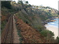
Railway between St. Ives and Carbis Bay
Image: © Andrew Abbott
Taken: 4 Nov 2008
0.05 miles
3
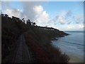
Railway to St Ives from Carbis Bay
Seen from a footbridge over the line. The railway follows a contour round Portminster Point, at the western end of the beach.
Image: © David Smith
Taken: 17 Jan 2014
0.08 miles
4
South West Coast Path, Carbis Bay
At the signpost, a footpath leads to the St Ives Road and continues to Knill's Monument. The path follows a private road which gives access to several houses.
Image: © David Smith
Taken: 17 Jan 2014
0.10 miles
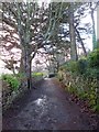
5
Footpath in Carbis Bay
This path links the A3074 with the South West Coast Path; it passes a garden with a treehouse
Image: © David Smith
Taken: 12 Mar 2016
0.11 miles
6
The north west end of Carbis Bay
Seen from the footpath above the bay.
Image: © pam fray
Taken: 16 Jun 2017
0.11 miles
7
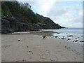
Rocks and beach at the western end of Barrepta Cove
Image: © Richard Law
Taken: 24 Dec 2021
0.12 miles
8
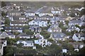
Carbis Bay : Houses on the hillside
From the coastal path looking across to the houses on the hillside.
Image: © Lewis Clarke
Taken: 2 Jul 2011
0.12 miles
9
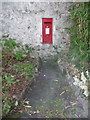
St. Ives: postbox № TR26 110, St. Ives Road
An Elizabeth II-reign postbox set into a wall that is nowadays somewhat hidden around the side of the roundabout for the Tesco supermarket turning.
Image: © Chris Downer
Taken: 16 Oct 2013
0.12 miles
10
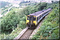
St. Ives branch line at Carbis Bay
A diesel multiple unit train on the branch line to St. Ives.
During the week that this image was taken, a total solar eclipse occurred over the far south west of England. This attracted large numbers of visitors. The train operator ran longer trains than normal on some of its services in Devon and Cornwall, including the St. Ives branch line.
Image: © Malc McDonald
Taken: Unknown
0.12 miles