IMAGES TAKEN NEAR TO
Boskerris Road, TR26 2RN
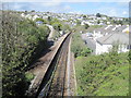
Introduction
This page details the photographs taken nearby to Boskerris Road, TR26 2RN by members of the Geograph project.
The Geograph project started in 2005 with the aim of publishing, organising and preserving representative images for every square kilometre of Great Britain, Ireland and the Isle of Man.

There are currently over 7.5m images from over14,400 individuals and you can help contribute to the project by visiting https://www.geograph.org.uk
Image Map
Images are licensed for reuse under creativecommons.org/licenses/by-sa/2.0
Notes
- Clicking on the map will re-center to the selected point.
- The higher the marker number, the further away the image location is from the centre of the postcode.
Image Listing (90 Images Found)
Images are licensed for reuse under creativecommons.org/licenses/by-sa/2.0
Image
Details
Distance
1
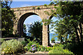
Carbis Bay Viaduct
Looking down through the railway viaduct towards the sea.
Image: © Pierre Terre
Taken: 19 Jul 2008
0.01 miles
2
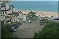
Carbis Bay
The St Erth to St Ives railway line crosses a small river valley on a viaduct, with a view down towards the Carbis Bay Hotel and the bay itself.
Image: © Graham Horn
Taken: 1 Jul 2011
0.06 miles
3
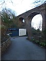
Railway viaduct and gig racing club, Carbis Bay
The viaduct carries the line over the valley of the Carbis Bay Stream. The building houses the equipment of the local gig racing club.
Image: © David Smith
Taken: 17 Jan 2014
0.06 miles
4
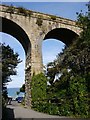
Carbis Bay, Railway Viaduct
The pier close to the road carries a cut bench mark close to ground level. See http://www.geograph.org.uk/photo/5159441 for a close-up and http://www.bench-marks.org.uk/bm79670 for details of the mark.
Image: © Brian Westlake
Taken: 9 Oct 2016
0.06 miles
5
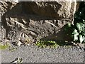
Cut Mark: Carbis Bay, Railway Viaduct
A cut bench mark close to ground level on the pier of the viaduct. See http://www.geograph.org.uk/photo/5159439 for a wider view and http://www.bench-marks.org.uk/bm79670 for details of the mark.
Image: © Brian Westlake
Taken: 9 Oct 2016
0.06 miles
6
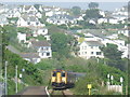
Carbis Bay station
The train from St Ives approaching Carbis Bay station
Image: © Malc McDonald
Taken: 5 May 2007
0.06 miles
7
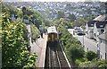
St Ives train at Carbis Bay station
There are passengers for St Ives at Carbis Bay station
Image: © roger geach
Taken: 15 May 2010
0.10 miles
8
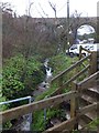
The Carbis Bay Stream
The short stream flows through the valley, under the railway viaduct. There is a stream gauging station close to the beach
Image: © David Smith
Taken: 17 Jan 2014
0.10 miles
9
Carbis Bay railway station
Viewed from the small residential road next to it.
Image: © Bill Boaden
Taken: 6 Jul 2014
0.10 miles
10
Carbis Bay railway station, Cornwall
Opened in 1877 by the Great Western Railway on its line from St. Ives to St. Erth. View north west towards St. Ives. The main building used to be at the top of the path on the left, where the cabin now is. There was only ever the single platform.
Image: © Nigel Thompson
Taken: 27 Apr 2012
0.10 miles