IMAGES TAKEN NEAR TO
Headland Road, ST. IVES, TR26 2NS
Introduction
This page details the photographs taken nearby to Headland Road, TR26 2NS by members of the Geograph project.
The Geograph project started in 2005 with the aim of publishing, organising and preserving representative images for every square kilometre of Great Britain, Ireland and the Isle of Man.

There are currently over 7.5m images from over14,400 individuals and you can help contribute to the project by visiting https://www.geograph.org.uk
Image Map
Images are licensed for reuse under creativecommons.org/licenses/by-sa/2.0
Notes
- Clicking on the map will re-center to the selected point.
- The higher the marker number, the further away the image location is from the centre of the postcode.
Image Listing (65 Images Found)
Images are licensed for reuse under creativecommons.org/licenses/by-sa/2.0
Image
Details
Distance
1
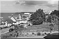
Headland Road, Carbis Bay, 1949
View from Hendra's Hotel. All the buildings on the left have since been replaced by modern apartment blocks, and the gardens in the foreground have been built over.
Image: © David M Murray-Rust
Taken: 20 Aug 1949
0.06 miles
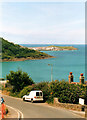
2
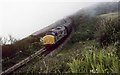
Preston to St Ives
A rail charter from Preston is seen approaching Carbis Bay station on what should have been a fine morning, but the sea mist has come in and spoilt the view. Next stop is St Ives. Locomotive hauled excursions to St Ives are very rare and there have been very few since.
Image: © roger geach
Taken: 17 May 1997
0.08 miles
3
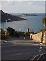
Carbis Bay: looking down Porthrepta Road
A fine view down this road, with St. Ives in the background.
Image: © Chris Downer
Taken: 14 Oct 2013
0.08 miles
4
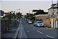
Carbis Bay : Headland Road
Headland Road between Porthrepta Road and a field at the end of the road.
Image: © Lewis Clarke
Taken: 2 Jul 2011
0.09 miles
5
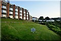
Carbis Bay : Grass sign & apartments
Nobody is supposed to walk on this grass so thankfully there is a path around it.
Image: © Lewis Clarke
Taken: 2 Jul 2011
0.09 miles
7
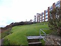
Flats overlooking Carbis Bay
A public footpath runs in front of the flats, above the railway line.
Image: © David Smith
Taken: 17 Jan 2014
0.09 miles
8
The railway above Carbis Bay
The branch line connecting St Erth and St Ives.
Image: © John Allan
Taken: 8 Sep 2019
0.10 miles
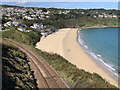
9
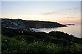
Carbis Bay : Railway & Coastline
Looking up the coastline close to the railway with a train approaching.
Image: © Lewis Clarke
Taken: 2 Jul 2011
0.10 miles
10
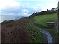
A public footpath above the railway line, Carbis Bay
Image: © David Smith
Taken: 17 Jan 2014
0.10 miles