IMAGES TAKEN NEAR TO
Great Carbona Close, ST. IVES, TR26 2FU
Introduction
This page details the photographs taken nearby to Great Carbona Close, TR26 2FU by members of the Geograph project.
The Geograph project started in 2005 with the aim of publishing, organising and preserving representative images for every square kilometre of Great Britain, Ireland and the Isle of Man.

There are currently over 7.5m images from over14,400 individuals and you can help contribute to the project by visiting https://www.geograph.org.uk
Image Map
Images are licensed for reuse under creativecommons.org/licenses/by-sa/2.0
Notes
- Clicking on the map will re-center to the selected point.
- The higher the marker number, the further away the image location is from the centre of the postcode.
Image Listing (29 Images Found)
Images are licensed for reuse under creativecommons.org/licenses/by-sa/2.0
Image
Details
Distance
1
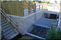
St Ives Flood Relief Works, Hellesveor
A flood relief scheme currently under construction beside Higher Stennack Road, where the Stennack River enters the western end of St Ives.
Image: © Pierre Terre
Taken: 20 Jul 2008
0.07 miles
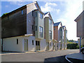
3

St Ives Porthia Town Sign on the Higher Stennack
Image: © Roy Hughes
Taken: 26 Jun 2016
0.09 miles
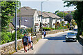
5
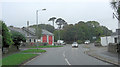
St Ives : Higher Stennack
Looking along a road.
Image: © Lewis Clarke
Taken: 29 Sep 2022
0.12 miles
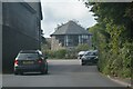
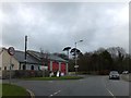
6
A3306, Higher Stennack passes The Community Fire Station
Image: © Stuart Logan
Taken: 9 Oct 2012
0.12 miles
8
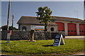
St Ives : Community Fire Station
St Ives Community Fire Station is an on-call fire station.
Image: © Lewis Clarke
Taken: 2 Jul 2011
0.12 miles
9
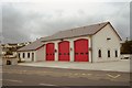
St Ives Fire Station
St Ives Fire Station, Higher Stennack, St Ives, Cornwall.
Image: © Kevin Hale
Taken: 26 Jul 1992
0.14 miles
10
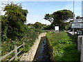
Channelled stream
At the junction of the B3306 and the B3311.
Image: © David Medcalf
Taken: 30 Aug 2013
0.14 miles