IMAGES TAKEN NEAR TO
Camaret Drive, ST. IVES, TR26 2BE
Introduction
This page details the photographs taken nearby to Camaret Drive, TR26 2BE by members of the Geograph project.
The Geograph project started in 2005 with the aim of publishing, organising and preserving representative images for every square kilometre of Great Britain, Ireland and the Isle of Man.

There are currently over 7.5m images from over14,400 individuals and you can help contribute to the project by visiting https://www.geograph.org.uk
Image Map
Images are licensed for reuse under creativecommons.org/licenses/by-sa/2.0
Notes
- Clicking on the map will re-center to the selected point.
- The higher the marker number, the further away the image location is from the centre of the postcode.
Image Listing (124 Images Found)
Images are licensed for reuse under creativecommons.org/licenses/by-sa/2.0
Image
Details
Distance
1
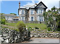
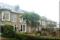
House on Belyars Lane
A lovely Edwardian house, now probably either flats or a guest house.
Image: © Graham Horn
Taken: 2 Jul 2011
0.06 miles
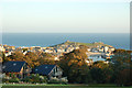
2
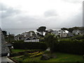
Houses & St Ives Bay from Higher Trewidden
This view is from one of the highest-located houses in St Ives.
Image: © Ruth Sharville
Taken: 6 Oct 2006
0.11 miles
7
St Ives beyond the chalets on the Tregenna Estate
Image: © Andy F
Taken: 17 Oct 2009
0.13 miles
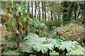
8
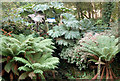
Ferns and gunnera on the woodland walk, Tregenna Estate
Image: © Andy F
Taken: 17 Oct 2009
0.14 miles
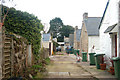
9
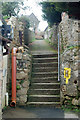
Steps and alley behind Albany Terrace, St Ives
Image: © Andy F
Taken: 7 Feb 2010
0.14 miles
10
Tree ferns and gunnera in the woodland, Tregenna Estate
Image: © Andy F
Taken: 17 Oct 2009
0.15 miles