IMAGES TAKEN NEAR TO
Hain Walk, ST. IVES, TR26 2AF
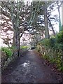
Introduction
This page details the photographs taken nearby to Hain Walk, TR26 2AF by members of the Geograph project.
The Geograph project started in 2005 with the aim of publishing, organising and preserving representative images for every square kilometre of Great Britain, Ireland and the Isle of Man.

There are currently over 7.5m images from over14,400 individuals and you can help contribute to the project by visiting https://www.geograph.org.uk
Image Map
Images are licensed for reuse under creativecommons.org/licenses/by-sa/2.0
Notes
- Clicking on the map will re-center to the selected point.
- The higher the marker number, the further away the image location is from the centre of the postcode.
Image Listing (22 Images Found)
Images are licensed for reuse under creativecommons.org/licenses/by-sa/2.0
Image
Details
Distance
1
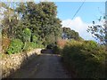
South West Coast Path on the west of Carbis Bay
The path follows a private road from Carbis Bay to Portminster Point
Image: © David Smith
Taken: 17 Jan 2014
0.03 miles
2
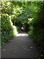
Coastpath Goes Inland A Little
The coast path between St.Ives and Carbis Bay goes inland a little after you leave St.Ives and after a while you come to this spot covered with trees.
Image: © Joe Pritchard
Taken: 10 Jul 2005
0.05 miles
3
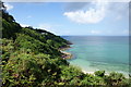
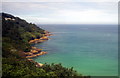
The coastline west of Carbis Bay
Viewed from the South West Coastal Path, looking towards Porthminster Point.
Image: © Bill Boaden
Taken: 6 Jul 2014
0.06 miles
4
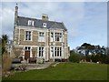
The south wall of Treloyhan Manor Hotel
A Victorian mansion on the edge of St Ives, now used as a Christian Guild hotel
Image: © David Smith
Taken: 12 Mar 2016
0.10 miles
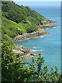
5
Porthminster Point
The rocky coast north of Carbis Bay, from the train.
Image: © Pierre Terre
Taken: 6 Aug 2006
0.12 miles
7
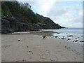
Rocks and beach at the western end of Barrepta Cove
Image: © Richard Law
Taken: 24 Dec 2021
0.17 miles
8
The north west end of Carbis Bay
Seen from the footpath above the bay.
Image: © pam fray
Taken: 16 Jun 2017
0.17 miles
9
South West Coast Path, Carbis Bay
At the signpost, a footpath leads to the St Ives Road and continues to Knill's Monument. The path follows a private road which gives access to several houses.
Image: © David Smith
Taken: 17 Jan 2014
0.18 miles
10
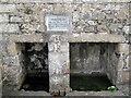
St Ives - Venton Ia
The Holy Well of St Ia. Until 1843 the main water supply for Downalong,St Ives
Image: © Roy Hughes
Taken: 23 Sep 2011
0.18 miles