IMAGES TAKEN NEAR TO
Bedford Place, ST. IVES, TR26 1SH
Introduction
This page details the photographs taken nearby to Bedford Place, TR26 1SH by members of the Geograph project.
The Geograph project started in 2005 with the aim of publishing, organising and preserving representative images for every square kilometre of Great Britain, Ireland and the Isle of Man.

There are currently over 7.5m images from over14,400 individuals and you can help contribute to the project by visiting https://www.geograph.org.uk
Image Map
Images are licensed for reuse under creativecommons.org/licenses/by-sa/2.0
Notes
- Clicking on the map will re-center to the selected point.
- The higher the marker number, the further away the image location is from the centre of the postcode.
Image Listing (582 Images Found)
Images are licensed for reuse under creativecommons.org/licenses/by-sa/2.0
Image
Details
Distance
1
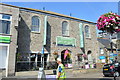
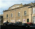
Former drill hall - Chapel Street
Recently converted to shop units.
Image: © John M
Taken: 9 Sep 2014
0.03 miles
3
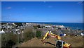
Construction above St Ives
Construction work high above St Ives in Cornwall, England.
Image: © Steven Haslington
Taken: 17 Apr 2016
0.04 miles
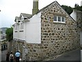
4
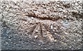
Ordnance Survey 1GL Bolt
This OS 1GL Bolt can be found on the front of the old Sunday school building. It marks a point 20.3972m above mean sea level.
Image: © Adrian Dust
Taken: 21 Feb 2017
0.04 miles
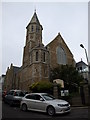
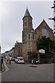
5
United Methodist Community Church, St Ives
Image: © David Smith
Taken: 17 Jan 2014
0.04 miles
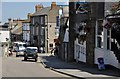
6
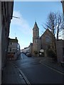
St Ives : Bedford Road
Looking up Bedford Road with the United Methodist Community Church in view.
Image: © Lewis Clarke
Taken: 16 Jul 2015
0.04 miles
8
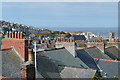
Across the rooftops 1
A view from The Stennack where it rises to the south of the town.
Image: © Graham Horn
Taken: 1 Jul 2011
0.04 miles
9
St Ives Theatre (former Wesleyan Chapel)
Image: © Paul Barnett
Taken: 2 Feb 2014
0.04 miles
10
St Ives : The Stennack
A road which heads down into St Ives and along the coastline. The Sheaf of Wheat can be seen on the right.
Image: © Lewis Clarke
Taken: 2 Jul 2011
0.04 miles